Visorando is a mobile mapping app and website, with a focus on walking and biking routes. It is very popular in France, and developing a growing user base in the UK now too. It’s main functions are to find, prepare and share routes.
Overview: Pros and Cons
What’s good about it?
- Simple interface
- Free to use with option to upgrade for additional features
- Detailed, moderated route descriptions
- Easy to switch back and forth between OpenStreet and OS Maps (premium feature)
- Can download routes as PDFs for printing
- Cool “Go to starting point” feature linked to Google Maps
What could be added to make it better?
- Satellite map layer not currently available for UK
- Route planner has no auto-plot function
I first came across Visorando whilst visiting France and looking for ideas for walks near by. A quick Google search for “walks near Nice” took me onto the Visorando website and I was soon reading about potential options. It found just what I needed: a map of the route and a full turn-by-turn description (in French, but that was ok for me).
Fast forward a few years and Visorando has arrived in the UK with an English-version of the website and an app.
It was good timing, because I wasn’t really enjoying the app I was using and kept saying I needed to look for an alternative. For 6 years I used Viewranger and recommended it to everyone who would listen. They were bought over by Outdooractive and eventually the Viewranger app was closed. I tried to get used to Outdooractive, give myself time to find all the features I had known and loved about Viewranger but as time went on I felt frustrated with it. It just seemed so complicated and nothing was where I thought it would be.
Visorando is different. It is so simple to use and that is one of the reasons I like it so much. More on that below.
Do you have to pay to use Visorando?
It is free to download and use. There is a premium version available called Club Visorando which you can subscribe to and benefit from advanced features. At the time of writing everyone automatically receives free access to Club Visorando for 3 days when you first register. This gives you a chance to try out all the features and if you miss any of them after the trial period, you can either pay monthly or annually to subscribe.
Through Gillian’s Walks you receive a longer free trial period as well as a discounted annual subscription when you attend one of my Introduction to Digital Navigation walks. You can find dates and locations for these on my website.
Find Walks
One of the main advantages I have found with Visorando over other mapping websites is the high quality routes which you can find on it. Each one has been moderated by a member of the Visorando team before going live on the site. This means that you can have confidence that the route you are following has been checked for accuracy and has a high quality route description.
I have personally added over 75 walking routes to the site, fully described and complete with waypoints.
You can either use the Gillian’s Walks website to find walking routes, or the Visorando app.
Finding walks using Gillian’s Walks
Go to the Gillian’s Walks website and search for a walk either using the search bar or one of the category filters. Open your chosen route. Scroll down until you get to the purple download button (“Download/follow this route on your mobile”). Click the button and the Visorando app will open at the correct route map.
If it is one of the 75 routes which have already been moderated, you will have access to both the map and the detailed description from within the Visorando app. Otherwise, you will notice that the Details tab is empty. You can still see a full route description on Gillian’s Walks website, beneath the purple button.
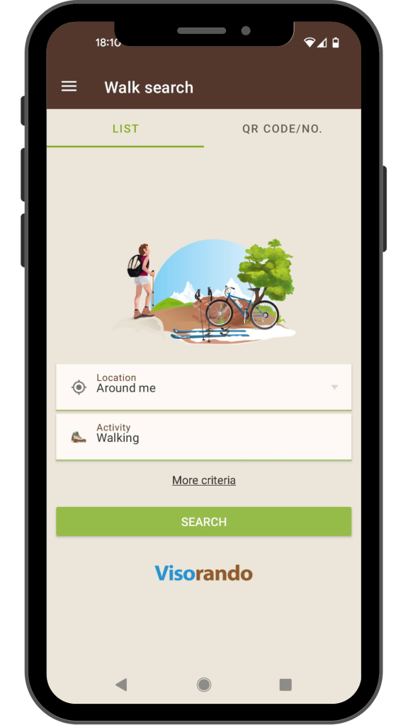
Finding walks using the Visorando app
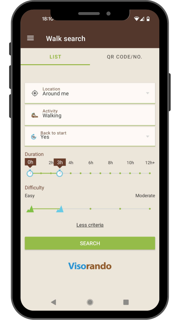
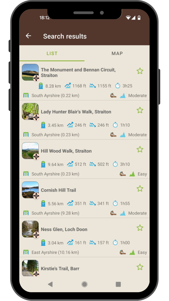
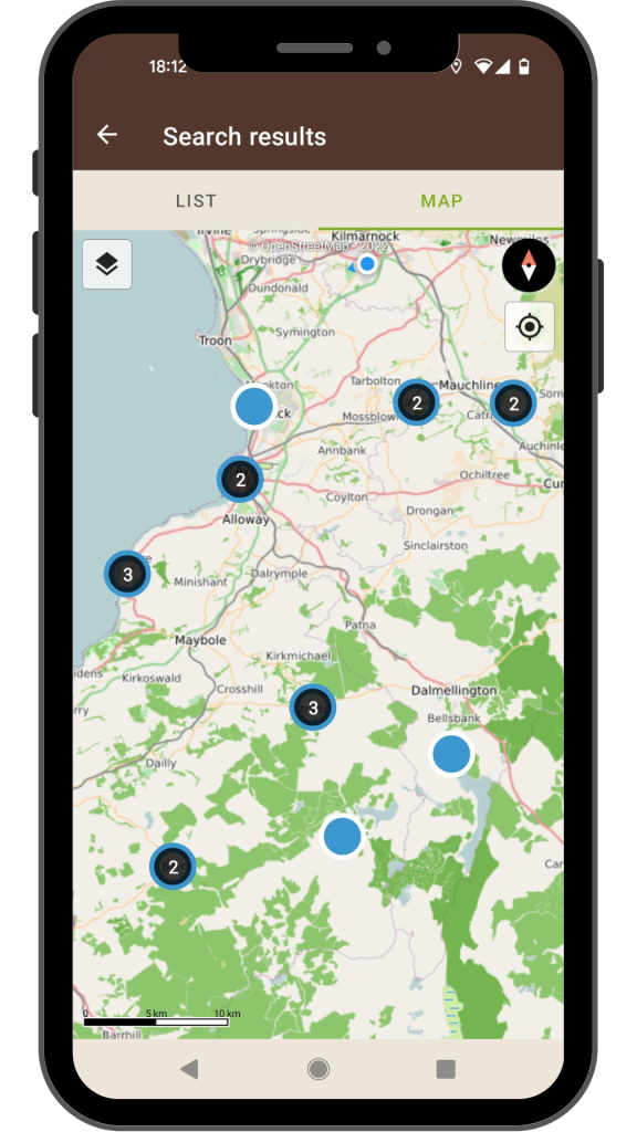
The app opens on the search screen. Simply enter your desired location and activity and click search to see a list of routes which meet the criteria you entered. All the routes shown to you have been added by a contributor such as myself and have been moderated by one of the Visorando team. If the list is long, you can further refine the search by entering additional criteria such as duration and difficulty level, and whether or not you want to see only circular walks.
There is also a map view if you prefer to have a visual of where the walks are within the area you searched.
If there aren’t any walks which match your search criteria, try searching on Gillian’s Walks instead – see section above for instructions. There are over 200 routes on there and not all of them will appear in the Visorando search screen (because I have not submitted them all for moderation), however you can still access the map by navigating to Visorando from my website.
A really cool feature of the Visorando app is “Go to the starting point”. Once you have chosen a route, click on “Go to the starting point” and the Google Maps app will open up, ready to take you to the start of the walk from wherever you might be at the time!
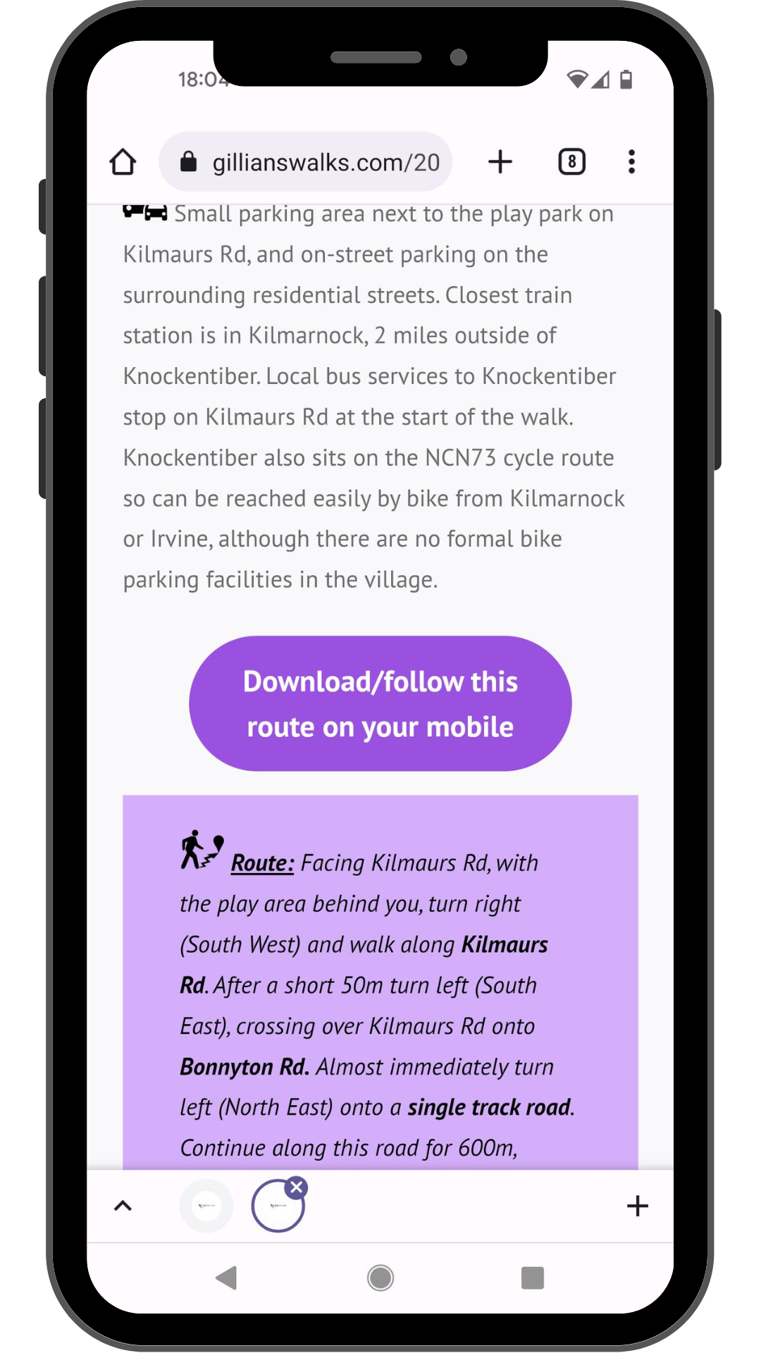
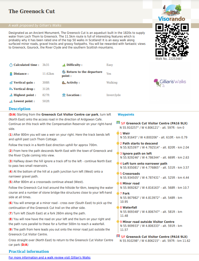
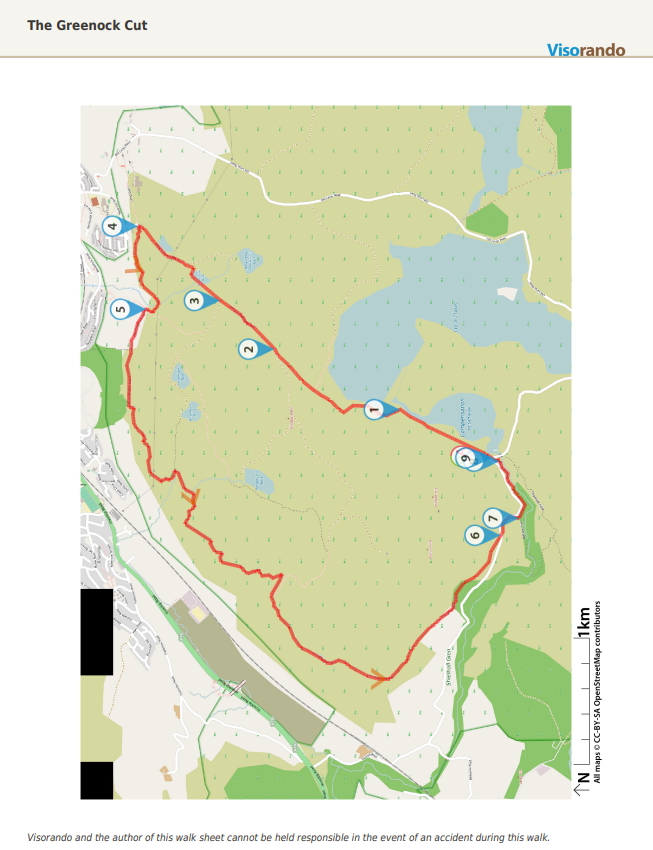
You also have the option to download a PDF from the Visorando app or website. This can be printed and taken with you on your walk. Here is an example of how that might look:
Prepare Walks
Once you have tried following some of the routes suggested by Gillian’s Walks or one of the other contributors, you might want to have a go at plotting your own using Visorando’s free walking route planner.
I find it easiest to do this on the desktop version of the site rather than the app. Use the “Go To” box at the top to navigate to your start point and then click on the screen to plot your route. As you plot your route you are able to keep track of the distance, ascent and descent and estimated walk duration.
Warning: if you are anything like me, route planning is a lot of fun and can quickly become addictive! I love planning out my routes before I head out for a walk. Knowing exactly what distance I am doing and how long the walk is likely to take gives me confidence that it will be within my capabilities and available time.
Follow Walks
Whether you have plotted out your own route or are trying one suggested by someone else, the next step is to go out and follow it.
I recommend downloading the route for offline use whilst you are somewhere with an internet connection. All mobile mapping apps use GPS signal to locate you, however they need some mobile signal to load the map to start with. If you have downloaded the map for offline use it means that you will still be able to view and follow the route even if you get there and have no signal at all. You can find instructions on how to save a map for offline use on the Visorando website.
Once at the start point, with the app open at the correct route click on the Start button (Apple) or click on the + symbol then choose “Start the walk” (Android). Then just start walking! The app will keep track of your location and start a trace of where you walk. Check the map regularly to make sure that your trace matches your intended route.
To stop the trace at the end of your walk, click the Stop button (Apple) or click on the + symbol then choose “Finish this walk” followed by “Stop” (Android).
Free vs Club Visorando Premium
Free
- Worldwide OpenStreet maps including walking and cycling layers
- Access to over 2000 pre-plotted route suggestions with maps and detailed descriptions
- Walking route planner
- Unlimited offline downloads
- PDF download option
Club Visorando Premium
- OS Maps UK
- Topographic map layers for France, Belgium, Switzerland and Spain
- Real-time position sharing
- Ad-free experience
- Advanced map customization features
- Sort and classify your saved walks into folders
- Export tracks on Google Earth
This post is sponsored by Visorando. All opinions are my own and a true reflection of my experience using the Visorando app and web platform. If you’d like more information about my affiliation with Visorando I can be contacted via the link in the footer of this page.
