TERRAIN: some muddy trails and field edge “paths” as well as 3 stile crossings.
![]() PLEASE AVOID USING THE CAR PARK AT CAPRINGTON GOLF CLUB IF IT IS BUSY WHEN YOU ARRIVE. There is plenty of on-street parking available in nearby Shortlees or Caprington residential areas, a short walk from the start of the route. It is also easily accessible by public transport with bus stops on the Ayr Road.
PLEASE AVOID USING THE CAR PARK AT CAPRINGTON GOLF CLUB IF IT IS BUSY WHEN YOU ARRIVE. There is plenty of on-street parking available in nearby Shortlees or Caprington residential areas, a short walk from the start of the route. It is also easily accessible by public transport with bus stops on the Ayr Road.
View Full Route Description
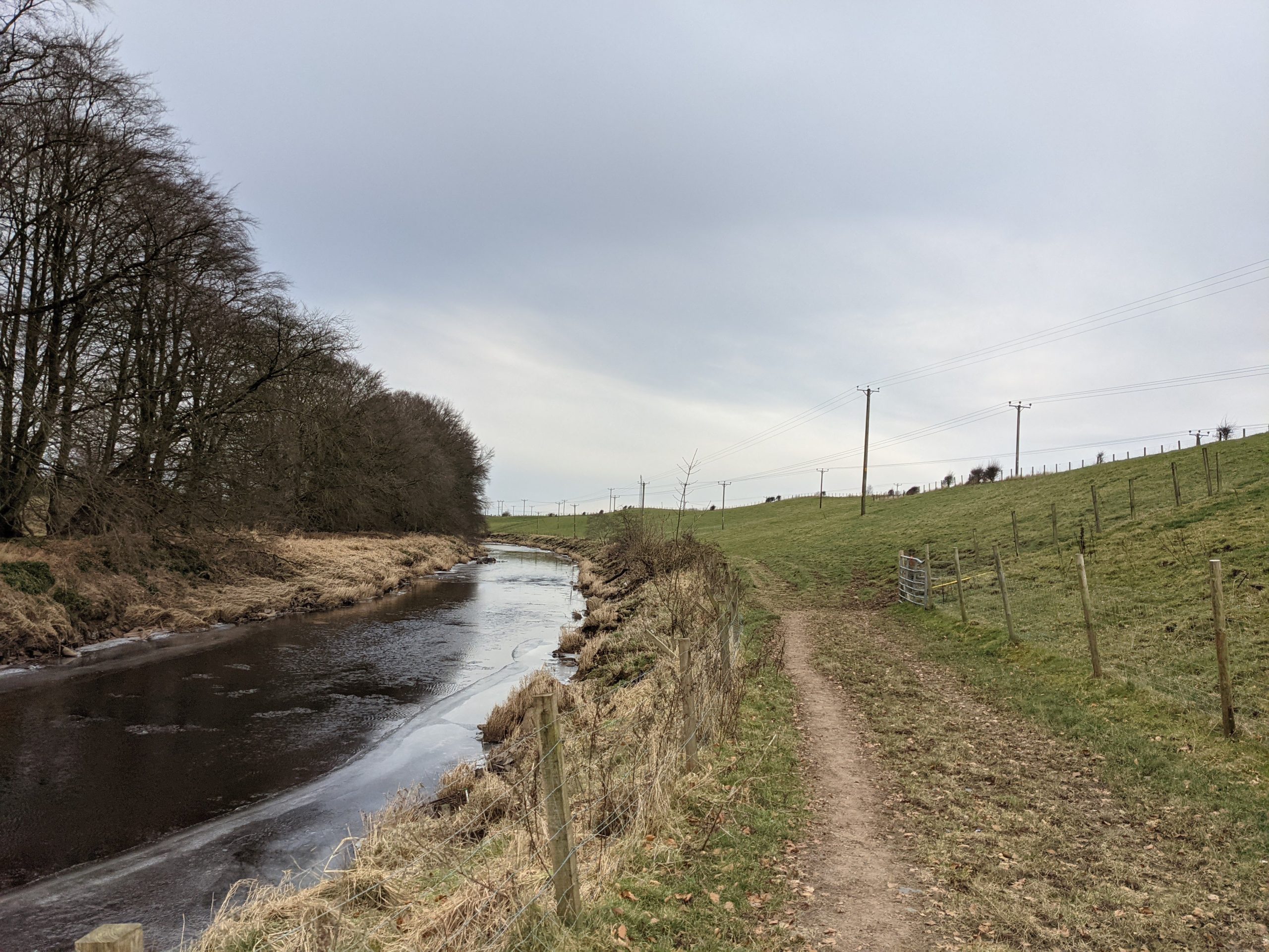
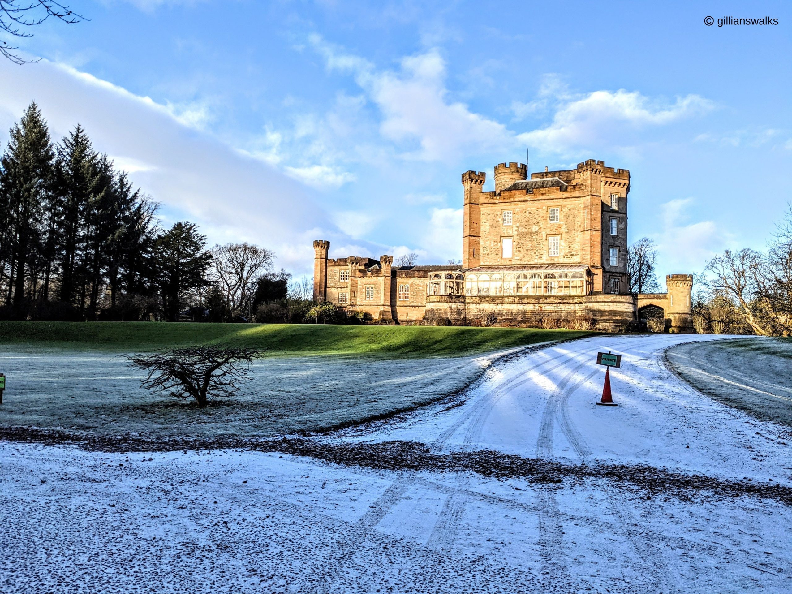
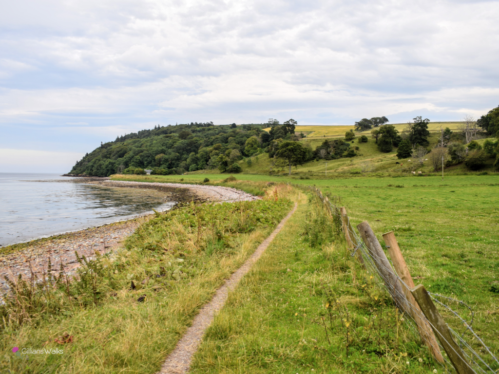
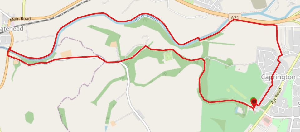
Facing the Clubhouse in Caprington Golf Club car park, follow a lane on your right-hand side which leads North East along a fence line and into a residential area. Turn right (South East) onto Todrig Drive then left (North East) onto Inchgotrick Road. Just as Inchgotrick Road starts to bend to the right 280m along, there is a lane on your left-hand side. Cut through the lane to reach Cunninghame Drive. Cross over Cunninghame Drive onto Scargie Road and follow this as far as you can. At the end of the street pick up another lane, this time leading onto Darnley Drive. Turn right (North East) on Darnley Drive then take the first road on your left – Maxholm Road. At the very end of Maxholm Road look out for an earth footpath leading into the trees ahead. This footpath runs parallel to the A71 for 500m before bending to the left and following close to the River Irvine for 1km. When you arrive at a large bridge, cross over the River Irvine and immediately pick up an earth path on the left (West) which heads along the side of the river (river should be on your left). The path ends quite abruptly at a stile approx 500m along – cross this and continue to follow the course of the river close to the edge of a field. Where the path narrows too much on the riverbank, you can use one of the many available metal gates to enter the field. Note that the field sometimes has livestock in it. You will soon reach a fence which you need to cross (used to be a stile but the foothold is broken) and there is then a stone plank to cross a small burn – cross with care then after another stile continue along the field edge. The river should be close to your left-hand side this whole time. Go through a kissing gate to the left of some high metal fencing. The vegetation along the path here can become overgrown in summer months. You will arrive onto another field – stick to the edge of it, keeping the river close to your left-hand side, to head towards a red sandstone bridge visible ahead. At the bridge, a set of steps takes you up onto the pavement beside the A759. Turn left (South) to cross the bridge and then take first road on your left (signposted Earlston, Caprington). Follow this road uphill for 1.4km, passing Old Rome Cottages and several farms. Shortly after walking beneath an old stone bridge you will arrive at a crossroads. Take the middle road – straight ahead (East) – which leads towards the former gatehouses for Caprington Castle. Pass through the gated entrance and continue straight ahead. Caprington Castle will soon come into view at the bottom of the hill. At the closest point to the castle, turn right (South East) to cross Todrigs Burn and continue along the castle driveway. Note the walled garden on your right-hand side as you walk along. After approx 700m, at the end of the field, you will reach a fork in the path – turn right (East) down a wide gravel track (often muddy!). Keep right (South) at another fork soon after. Follow the track for just over 1km to arrive back at Caprington Golf Club car park.
WALK REPORT: 13TH FEBRUARY 2021
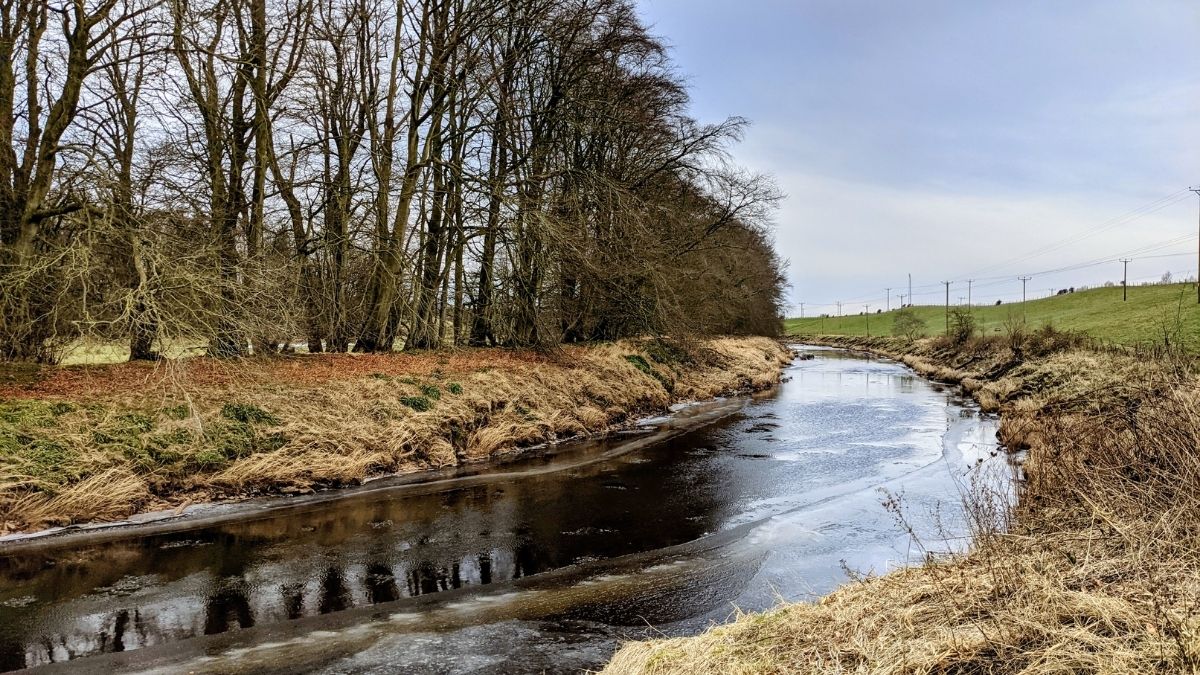
My plan had been to show Mum what had become one of my go-to lockdown routes though Caprington woods, past the castle, through Earlston and then back across the golf course. Roughly an hour of walking, maybe a bit more. When we reached the bridge over the River Irvine we stood on it admiring the frozen water and I pointed out a footpath leading off it and explained that it was the way to Gatehead. “Do we have time to do it now?” came the response. We did…. so we did!
One of the coldest days of the year at -8, some of the river had frozen but only the very top layer as we realised when we witnessed a leaf floating down the water beneath the surface. Life goes on….
Ayrshire had missed all the snow which had fallen across (what felt like) the entire rest of Scotland this week, but what we had experienced was very cold temperatures and dry air. So much so that the ground was bone dry. All the normally boggy areas were dry and solid. Not in an icy way though, more like what you would expect after a dry spell in the summer. It was quite bizarre. It was also most helpful during the field crossings! With it being early in the year there was no livestock in the fields when we crossed, but there has been on previous occasions when I’ve walked this route so something to be aware of. In the final field there was evidence of crops but there was loads of space around the field edge to walk without disturbing them.
With the water levels being so low, at various points along the route we could see the scale of the litter problem in the River Irvine. There were trees with plastic enveloping their trunks where the river level had once been so high as to sweep past them and the sheets of plastic and other debris became lodged. There were several large items which had washed up onto the field, including a waste disposal unit from a caravan. In the river itself we saw several trolleys and a couple of buggies, old tyres and lots (lots!) of plastic…. It saddens me to witness this in a fairly remote section of the river and hammers home the fact that over 90% of plastic in Scottish seas comes from littering on land!!!! We humans have a lot to answer for. I’ve heard reports of otters being spotted along the river here, and regularly see a grey heron looking for it’s dinner. There must therefore be fish in the river – having to live amongst all that. Earlier in the walk we had passed an area known for fly tipping and there were 2 rabbits playing around in the bushes, surrounded by human rubbish. It got me to thinking about the fact that I show off these walks on my website at their best: The photos I select are of everything looking pristine and beautiful and enticing. Maybe I should be showing the reality? But who wants to see photos of litter coming up on their Insta feed? Not me, for one. *Sigh* There is much to be done, not least a whole generation to educate. It is something I’d really like to be involved with if I had a little more time.
Anyway, back to the route! Leaving the river behind at the end of the last field, we climbed the steps onto A759. We smiled at the makeshift banister someone had created – very useful indeed so thank you whoever you are!
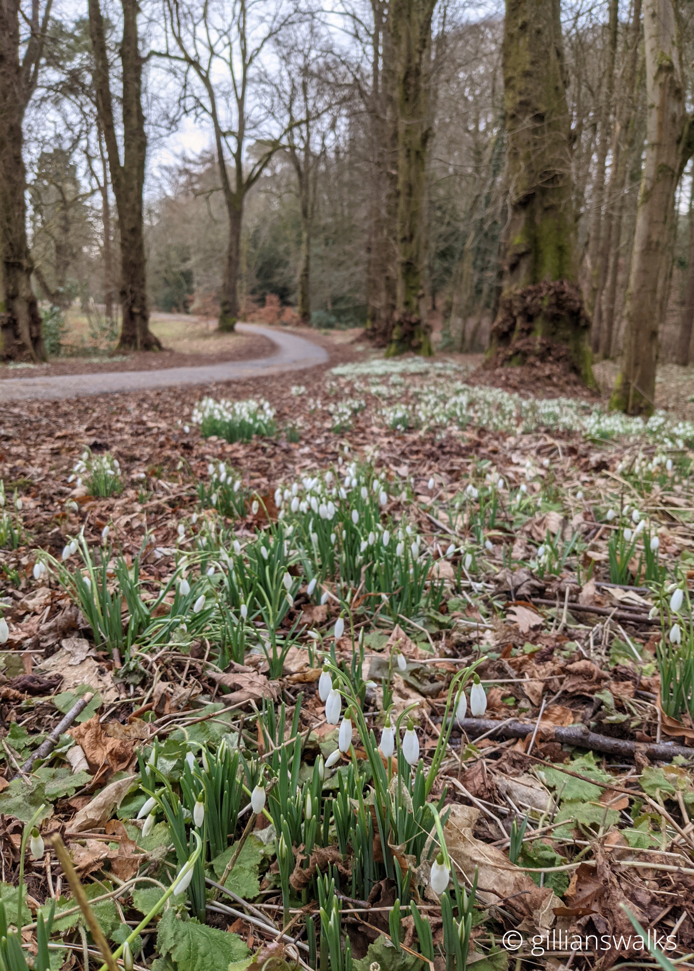
A short section of pavement awaited and we were onto the back road between Gatehead and the Ayr Road in Kilmarnock. Only a few cars passed us on this quiet country road, and we were soon back in the grounds of Caprington Estate. Carpets of snowdrops were on display along the main drive, and the usually very muddy path back to the Golf Club was lovely and dry. Result! Passing the castle, as I do frequently, always brings back memories of leading walks here as a volunteer for the Active Travel Hub Kilmarnock. I loved the reaction of walkers in the group when they saw the castle for the first time, having lived in Kilmarnock all their lives and not knowing it existed :-).