DIFFICULTY RATING: moderate. A mix of good firm sandy beaches and rocky beaches, sometimes with seaweed for a short stretch, which can make things slippery. Woodland earth paths inside Culzean Castle Country Park – if following the cliff walk these can be uneven due to tree roots and also moderately hilly by nature. Steep walk up Hairpin Brae to grassy field-edge tracks which are uneven in places and can be hard-going or very easy depending when they were last mown. Boggy in places. Several kissing gates. High possibility of livestock, normally sheep. One footbridge with steps down onto it. On approach to Dunure there is a set of steps with no handrail and some of the steps are quite deep.
**It is important to check tide times before setting off on this walk: for 2 hrs either side of a high tide Isle Port, at the north end of Croy Shore, is usually impassable**
![]() Dog-friendly walk (Note sheep sometimes in clifftop fields – please be a responsible walker)
Dog-friendly walk (Note sheep sometimes in clifftop fields – please be a responsible walker)
![]() Car park at Maidens Harbour and Kennedy Park Dunure (chargeable, seasonal). Bus services to Maidens and Dunure (but not directly between the villages, need to go via Ayr).
Car park at Maidens Harbour and Kennedy Park Dunure (chargeable, seasonal). Bus services to Maidens and Dunure (but not directly between the villages, need to go via Ayr).
![]() Toilets options on this route: Ropes Bistro at Maidens Harbour, Culzean swan pond, Culzean Castle, Kennedy Park Dunure (check opening times and charges on the SAC website)
Toilets options on this route: Ropes Bistro at Maidens Harbour, Culzean swan pond, Culzean Castle, Kennedy Park Dunure (check opening times and charges on the SAC website)
![]() Purchase the official Ayrshire Coastal Path Guide Book
Purchase the official Ayrshire Coastal Path Guide Book
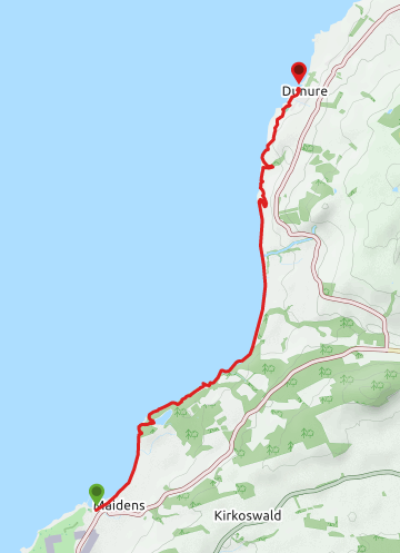
View full route description
From the car park at Maidens Harbour, head NE along a surfaced path towards a footbridge over a burn. Cross the bridge and continue along the path, dropping down onto the sandy beach of Maidenhead Bay when you reach a ramp.
Walk N along the sandy beach for 1km to the mouth of a burn. If you are unable to ford it, turn right (E) here and use the footbridge then turn left (W) to return to the beach.
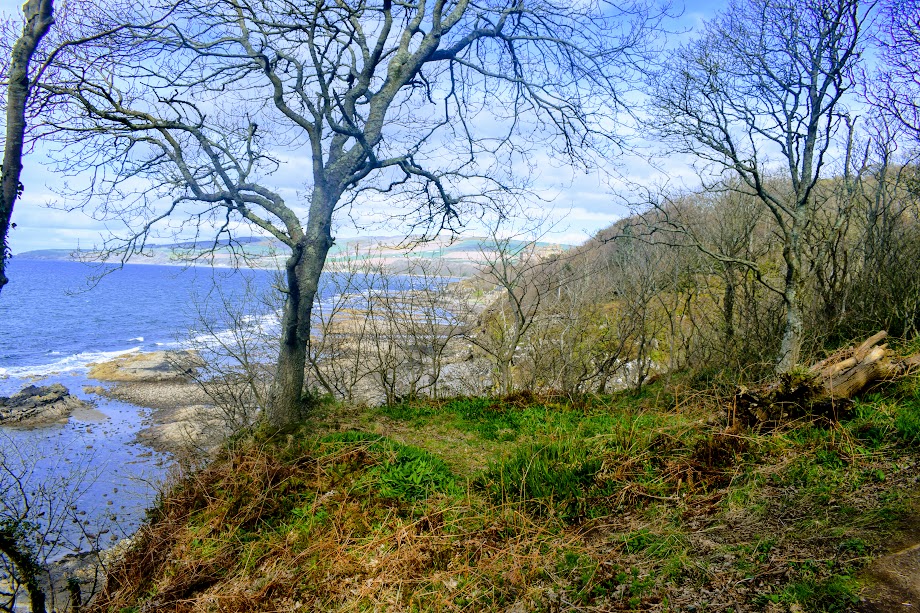
Continue North along the beach for a further 300m towards a rocky outcrop. Just before the end of the bay look out for some boardwalk and steps on your right-hand side – go up these to access Culzean Castle & Country Park. At the top of the steps keep left at two forks and follow the earth footpath around the clifftops.
After 500m you will arrive on the banks of the Swan Pond. Turn left (N) to cross a burn then almost immediately after, at a fork, turn left (N) onto an earth footpath signposted “Cliff Walk“. The footpath leads you uphill through pleasant woodland.
After 600m at a fork keep left (NE) to continue along the cliff edge. A further 300m along after the path begins to head away from the cliff edge, you will reach a path junction. Turn left (NE).
Over the course of the next 100m ignore three paths off to your left and right: first a path to the left (NW), which goes to the Powder House, then a path to your right (S),and lastly a path to the left (NW), also going to the Powder House.
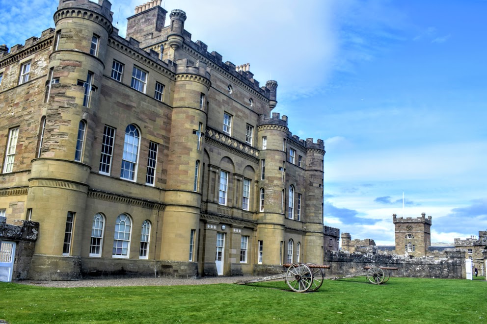
When you reach a minor road turn right (NE) for 60m then turn left (N) onto a footpath which leads to an open grassy area. Culzean Castle will be visible ahead. Cross the grass in the direction of Culzean Castle to reach a gap in the wall. Go through the gap and into a small parking area and onwards along the road past the rear of the castle to a viewpoint.
Exit this area to the SE of the ’roundabout’ through a stone archway. Turn left (N) and follow a footpath directly in front of you, heading downhill.
Go down two sets of steps to the Gas House and then down onto the sandy beach. Follow the bay north, picking up a woodland path in the trees 280m along which helps you get around the rocky foreshore, before leading you back onto the beach just beyond a holiday cottage.
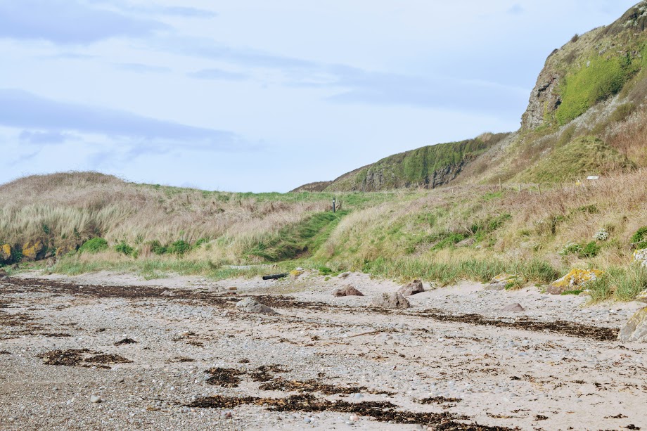
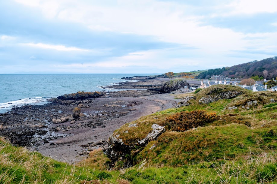
Walk along the beach for 3km as it sweeps past Croyburnfoot Caravan Park and a further 800m along look out for an Ayrshire Coastal Path way-marker on the right-hand side, directing you up the cliff side via ‘Hairpin Brae’.
At the top of the hill go through a kissing gate and follow the field-edge, cliff-top route for 1.5km, passing a wartime lookout tower, before beginning a descent into the village of Dunure via Millennium Woods. Follow the track through the trees and down some steps.
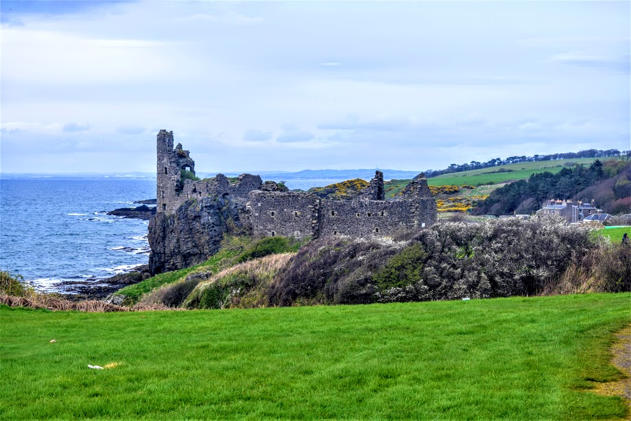
Keep right (N) at a fork just along from the bottom of the steps. You will soon arrive at the entrance to Kennedy Park. Follow the track across the grass, past a toilet block and kids play area, then head towards the remains of Dunure Castle on your left.
Go past the castle and dovecote, following a narrow trail across a small burn, beneath a limekiln and through a car park. At the end of the car park turn left (W) down a residential lane. At the end of the lane turn right (N) and you will arrive at Dunure Harbour where this walk ends.
WALK REVIEW: 10th April 2017 & 13th October 2024
When walking this route alone, the Maidens Harbour to Culzean Castle section took me just over one hour to walk. From there it was just over 2 hours into Dunure. Walking with a group, with lots of stops to talk about points of interest along the way, and you can add a couple of hours extra on to that!
There is an excellent free car park at Maidens Harbour right beside the start point of the walk. From here you can see the terrace of Ropes Bistro, up on the hillside. Ropes kindly offers the public use of their toilets during opening times, and comes highly recommended for a pre-walk coffee or lunch if you are starting later in the day.


The official (and therefore signposted) route of the Ayrshire Coastal Path comes off Maidenhead Bay at Hogston Burn where the caravan park ends, and heads all the way along ‘Long Avenue’ until you reach the castle. My personal preference is either to follow Long Avenue only until the Swan Pond (where there are toilets!), then head up onto the cliff walk, or alternatively, to stay on the beach until reaching the north end of the bay where there is a boardwalk and some steps up onto the cliff walk, also leading you to the castle. Far more exciting! I tend to favour less populated routes, and with today being a sunny bank holiday weekend I knew that the ‘easier’ trails would be busy. Another reason for choosing the cliff walk.
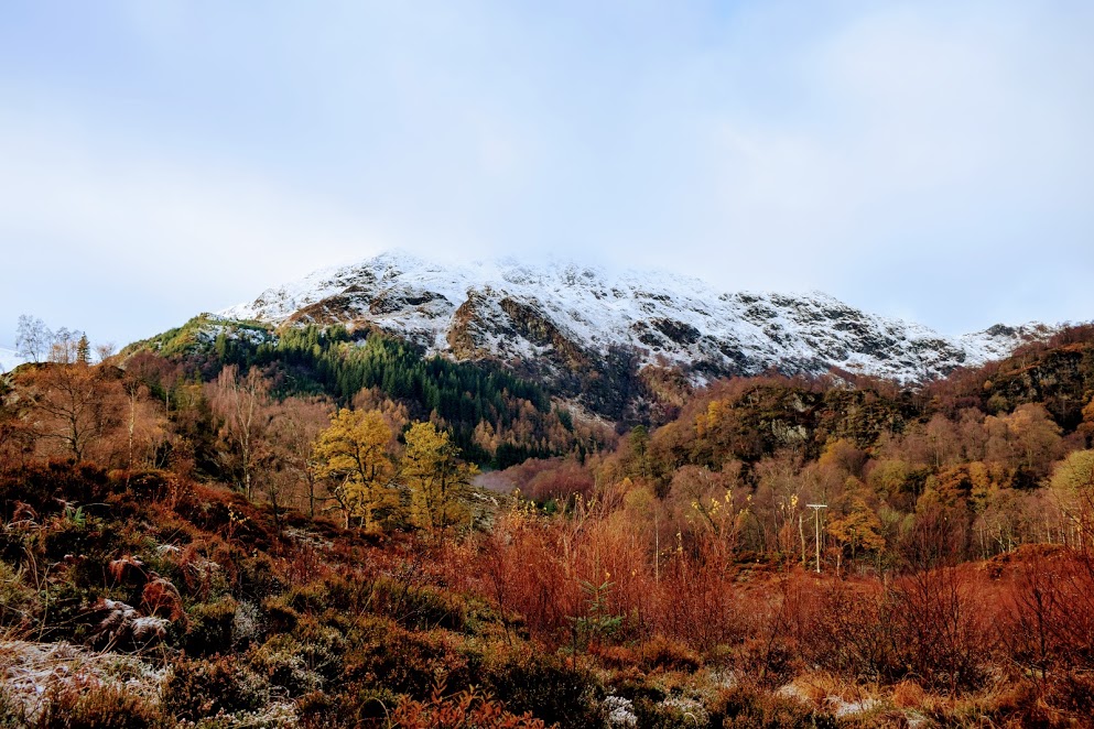
A beautiful woodland walk with many ancient trees, in particular some old oaks which grow outwards rather than upwards – the subject of many a family photo over the years! Thanks to the elevated position of the cliff walk, on a clear day you’ll be rewarded with stunning views across the glimmering silver water to Ailsa Craig.
Culzean Castle is of course one of the big highlights of this walk! You can’t help but be blown away by its elegance, its size and its history. On this walk you get to see the structure from pretty much every angle!
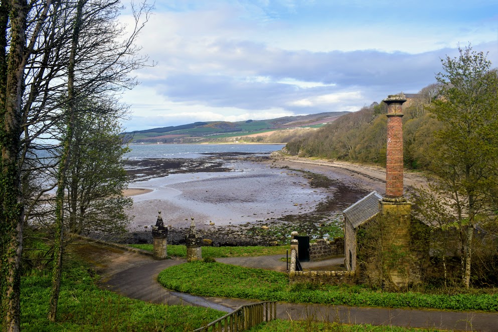
Before leaving Culzean Castle and Country Park there is one more historical building to note – the Gas House. This was where Culzean’s Gas Manager would have worked, turning coal into gas for heating and lighting. I have read that the same man worked here as Gas Manager for several decades, and lived in the cottage next door with his family! Both the cottage and Gas House are now small museums and when open offer a fascinating insight into the history of and process behind gas production.

Despite countless visits to Culzean as a child I can’t ever remember walking on the beach north of the castle, so on my first adventure along the Ayrshire Coastal Path here back in April 2017, I was really looking forward to that part. I had it pretty much to myself that day and wandered along taking time to enjoy the views. Culzean Castle looked even more grand from this angle, perched on top of the cliff at the end of the bay.

Stopping to take a few photos I suddenly realised that my sunglasses were no longer hooked onto my t-shirt collar. My Ray-Bans! I knew they had been there when I came down onto this beach at the Gas House because I distinctly remembered patting my chest to check and thinking to myself that I would be best to move them from there before they fell…… I paced that beach back and forth at least four times and could not find them 🙁 I was gutted! Have you ever tried to re-trace your steps on a soft sandy beach?? It is pretty difficult! Lesson learned….

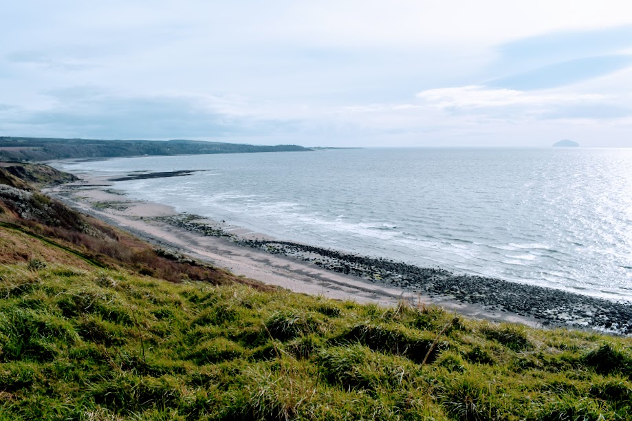
There is one part of this route which you must avoid for 2 hours either side of a high tide and that is the outcrop immediately north of Croyburnfoot Caravan Park. Listed on OS maps as Isle Port, the rocks here are impossible to get around at high tide, with water coming up to waist height at its peak. At low tide, when you can simply wander along firm sand, you’d have no idea that it could change so much! Check tide times at tidetimes.org.uk.

The next section takes you across the edge of some farmland, which can at times host sheep or crops. Usually the field-edge is kept “mown” by the land manager (who is also a Path Warden on this section of Ayrshire Coastal Path) so it never gets too overgrown. Again, the views were just spectacular from up there and I really got a sense of how vast an area this is and just how remote and rugged the coast is. I also pondered how lucky the farmers here are to have THAT view at their work!!


From the observation tower it is only a short 20 minute walk to Dunure through the Millennium Woods. The ruins of Dunure Castle come into view on the approach to Kennedy Park, and is a fine ending to this walk. If you have time I highly recommend visiting the castle – you will find information boards explaining some of the history of the building, and a special staircase inside it allows visitors to climb to the upper floor and take in the stunning coastal views.
Dunure village also has its very own labyrinth – can you find it?! Public toilets are available in Kennedy Park (seasonal, charges apply). Why not head to the Harbourside Cafe for some refreshments at the end of your walk, I can personally recommend it!