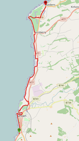
DIFFICULTY RATING: moderate. A mixture of pavements, farm tracks, sand or pebble beaches, rough pasture and a golf course crossing. Short inland de-tours are available at three points if necessary due to high tides or burns being in spate. These are at 1) Curragh Cottages where at high tide the bay is impassable without scrambling over large rocks. De-tour involves a surfaced road and field-edge. The field is normally used for crops but I have experienced cows there before in early autumn; 2) Dipple Burn beside the seaweed factory. De-tour involves a short stretch along the grass verge of the A77, 2 stiles, and some farm tracks; 3) Milton Burn at the south end of Turnberry village. De-tour involves steps up over the sand dunes, sandy/grassy footpath and a stile.
![]() Car park at southern end of Ainslie Park, Girvan (KA26 0HW) and at Maidens Harbour. Bus service between Girvan and Maidens. Girvan is also served by a train station.
Car park at southern end of Ainslie Park, Girvan (KA26 0HW) and at Maidens Harbour. Bus service between Girvan and Maidens. Girvan is also served by a train station.
![]() Public toilets at Girvan Harbour (start of walk) – check opening times and charges on the SAC website. Ropes Bistro in Maidens (end of walk).
Public toilets at Girvan Harbour (start of walk) – check opening times and charges on the SAC website. Ropes Bistro in Maidens (end of walk).
![]() Purchase the official Ayrshire Coastal Path Guide Book
Purchase the official Ayrshire Coastal Path Guide Book
View full route description
From Ainslie Park in Girvan head onto the promenade and walk north (with the sea to your left). After 1.8km, just beyond a large kids play area, you’ll arrive at a large fountain. Turn right (E) to walk through the car park towards the harbour.
Down by the harbour you’ll walk past the RNLI Girvan Lifeboat Station before reaching a set of steps. Go up the steps and onto Knockcushan Street. Turn left (E) and at the crossroads turn left again (N) onto Bridge Street. Take the first left (NW) onto a minor road. Turn left (SW) after only 100m to cross the River Girvan via Newton Kennedy Bridge.
At the other side of the bridge keep left (W) onto Newton Place, heading towards the shipyard. Just beyond the Coastguard Station turn left onto a footpath beside a landscaped rock garden. Follow the footpath around the perimeter of it, the water on your left-hand side, to reach the car park for Girvan Golf Course after 350m.
Follow the path right (E) here to walk around the outside of the car park. At the end of the footpath turn right to cross over onto a small street leading between some houses. Turn left (N) at the end of the street onto Golf Course Road.
Continue along this road, which skirts the perimeter of the golf course, for 1km until you reach a crossroads – turn left (NW). After 200m turn left (N) to walk through Girvan Mains Farm.
The next section is along a good farm track running parallel to the coast. About 1km along, shortly after passing the Girvan Waste Water Treatment Plant, the road begins to turn inland and a wooden marker post directs walkers left (N) along a wrack road.
After approx 1km you will arrive at a field gate. Depending on the time of year there might be bulls in the field – if not you will be able to walk through this and the next field to arrive at Curragh Cottages. If livestock is present, you will need to go down onto the pebble beach at this point instead.
At Curragh Cottages, you can either continue along the beach if the tide allows, or walk along the road in front of the cottages then along the edge of the field which you enter and exit via kissing gates at each end. Return onto the beach once out of the field.
1km beyond Curragh Cottages you will reach Dipple Burn. If the tide and depth of the burn allow, cross it and continue north on the beach.
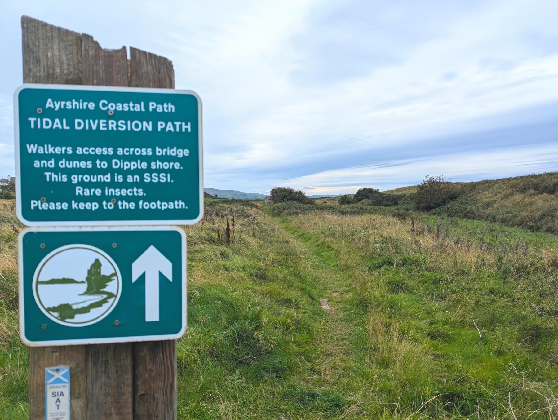
[If the burn is not fordable follow the inland de-tour as follows: turn right (E) along a track to reach the A77. Turn left (N) to follow a grassy verge in front of the factory building. Look for a gap in the stone wall after the bus stop (there is usually an orange traffic cone here but can be hard to see if vegetation growth is high). Follow the grassy track along to a stile. Cross over then turn right to walk around the field edge. At the end of the first field, opposite Dowhill Farm, turn left (W) onto a farm track taking you along the side of another field. Cross another stile to access the beach. This short tidal de-tour is fully way-marked.]
Continue north along the sandy beach for approx 1.7km to the Milton Burn, which flows out onto the beach at a large pipe. If the tide and depth of the burn allow, cross it and continue north on the beach.
[If the burn is not fordable follow the inland de-tour as follows: retrace your steps approx 200m back along the beach and look out for an obvious set of wooden steps built into the sand dunes. Go up the steps and through a kissing gate at the top of the hill. Follow a sandy/grassy trail down towards a small building then left along the base of the sand dunes to a stile. Cross the stile then turn left on a track to reach the beach.]
Continue north on the sandy beach for 1.3km, Turnberry Lighthouse visible ahead. On reaching a rocky outcrop at the north end of the bay, turn inland and follow the Ayrshire Coastal Path way-markers up to then across Turnberry Golf Course and out onto the A719.
Turn left (N) at A719 to walk along the roadside pavement for 1.2km to reach Maidens. Just past Hamilton Brothers car garage, turn left (W) down a lane which cuts through to Harbour Road. Cross the road and the car park, to find a footpath beside the water. Turn left along the footpath to reach Maidens Harbour, where this walk ends.
WALK REVIEW: 10th April 2017 & 15th September 2024
I first did this walk as part of my Ayrshire Coastal Path charity fundraiser. This was day 2 and I was walking from Girvan to Ayr, some 25 miles. This section of coastline wasn’t one I was very familiar with so I really enjoyed discovering it: The lifeboats in Girvan Harbour, the fields of Ayrshire tatties, the white sand of Turnberry Bay, the rugged coastline around Turnberry Lighthhouse, and walking across Trump Turnberry Golf Course. Isle of Arran also made an appearance and it was really strange seeing it from the south! Although not a cold day, it was blustery and I needed my winter hat for most of the way! The joys of coastal walking 😉
I have since walked this route many times, both on my own and with groups, and lots of people tell me it is one of their favourite sections. Why? Well, first up if you’ve been making your way along the Ayrshire Coastal Path from Glenapp, when you reach this section at Girvan you’ll definitely notice how flat it is compared to all the preceding sections. So it feels less challenging albeit the distance is the longest so far at 10 miles.
As well as that, you are spoiled in terms of interesting features!
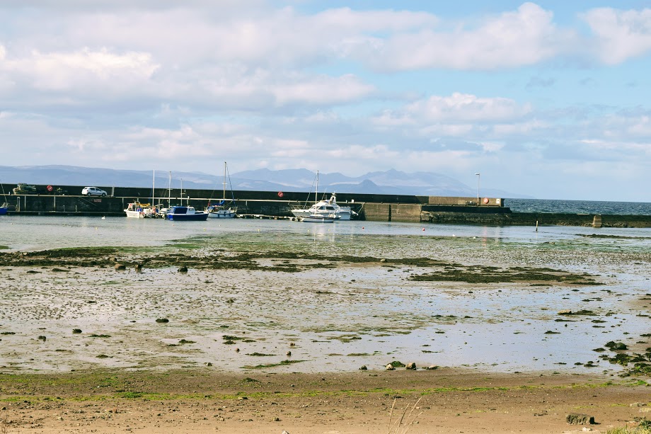
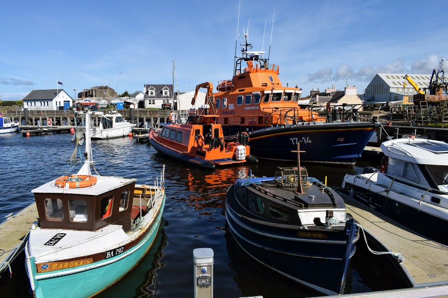
The first port of call is Girvan Harbour, which seems a hive of activity compared to the sleepy harbour at Ballantrae you will have encountered on a previous stage of the trail. Located at the mouth of the River Girvan you will see small fishing vessels berthed here, the RNLI Girvan lifeboats (which have been stationed here for over 150 years), and boats awaiting or undergoing repairs at Nobles Shipyard.
Opened in 1946, Nobles is one of only a few small shipyards remaining on the Clyde, and I have often enjoyed pausing here to watch them at work, hand-painting boats and carrying out repairs.
The Coastguard is also situated at Girvan Harbour. Look out for the resident swan family too!
The town of Girvan actually took its name from the River, and would have began as a small settlement around the mouth of the river supporting the herring fishing industry. The population of the town is now over 6,000!
Day-trippers can enjoy boat trips out to Ailsa Craig from the harbour – have you done this before? It is still on my bucket list!
The next point of interest is the rock garden at the former coal dock beside the Harbour. From 1837 until 1918, this area would have been used for the shipping of coal mined from Bargany and Dalquharran pits at Dailly. Girvan Rotary Club transformed the former dock in 2005 as a project to mark the centenary of Rotary International. It is grassy on top with benches for admiring the views, and has a well-maintained rock garden around the sides, which has been planted with shrubs and flowers and decorated over time with hand-painted pebbles and other features, such as these ‘brick books’!

We’ve barely walked half a mile so far and yet there has been so much to see!
I found navigation to be pretty easy on this walk thanks the the Ayrshire Coastal Path way-markers. I think the only place I’d advise extra caution is where you arrive at the small car park for Girvan Golf Course: in the absence of obvious signage you might be tempted to keep left and walk along a track on the edge of the golf course, since it is closest to the sea and you are afterall walking a coastal path. However you’d find yourself reaching a dead-end having to either retrace your steps or clamber over a wall and then lots of rocky beach. Not to mention the obvious risk of injury from golf balls!
The continuation of the Ayrshire Coastal Path from the small car park at the golf course is in fact to turn right, heading slightly inland along a small street between the row of houses on Golf Course Road. If you look closely you will see some Ayrshire Coastal Path directional arrow stickers on a lamp post at the start of that street. However I do feel that one of the larger metal signs would be prudent here, to catch the eye. In fairness, if you are following the instructions in the official Ayrshire Coastal Path Guide Book, an Ordnance Survey map, or my digital route map, then the intended route is clear. A good reminder not to rely solely on signage.
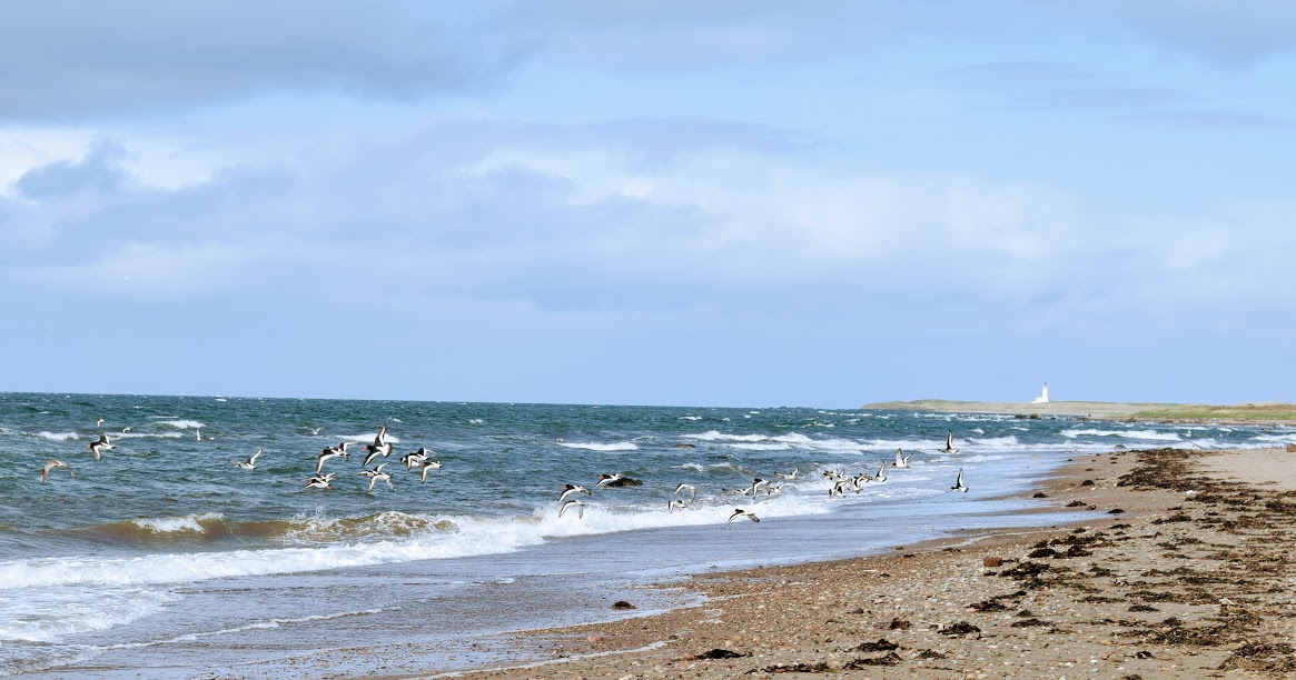
Beyond the golf course the walk takes you through Girvan Mains farmyard and onto a quiet road and track running parallel to the coast. You will see plenty of evidence of this being a busy working farm, with fields of crops (Ayrshire tatties, carrots, turnips to name a few), massive bulls (thankfully separated from the path by fences!), and farm equipment stored along the edge of the track. The coastline here is abundant in bird life such as Curlew, Oystercatchers and Cormorants. Ducks and Swans can also often be found in the waters along this section.
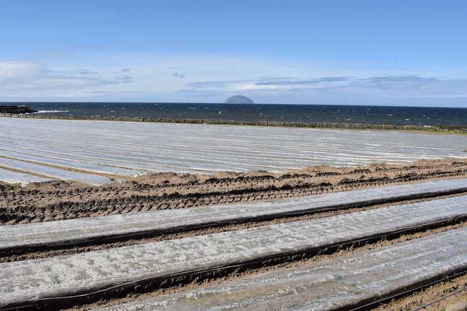
Ayrshire tatties have been grown here for over 100 years. They tend to be planted mid February and harvested May/June however this can continue right through to September. They are the earliest Scottish potato each year and considered among the finest in the UK. They grow well here due to the light sandy coastal soil, the mild climate due to the gulf stream (so not much frost), and the fertilisers used (traditionally seaweed and manure). Along the way you will pass an old sandstone quarry at Chapeldonan, now filled with water, and this is pumped to irrigate these fields. In the early 1900s, there would have been over a thousand “tattie howkers” (potato harvesters) in the Girvan area, but nowadays everything is done using modern equipment. The harvested potatoes need to be handled with care as their skins are so soft. Delicious boiled with a knob of butter!
At several points along this route you might notice some blue plastic barrels, such as the one pictured below. These were put in place by the Ayrshire Coastal Path volunteers in 2019, in response to the ‘Blue Planet’ TV series which highlighted the issue of plastic on the world’s coastlines and the devastating impact of this on our wildlife.
The bins were sited on remote areas of coastline and the idea is that as you walk along if you see any plastic waste you can pick it up and pop it into the next ‘blue bin’ you come to, thus doing your bit to help. The Path Warden for this section periodically empties the bins as part of their regular inspections, or when alerted to them being full by a local resident or trail walker.
There are always spare bags at the bottom of the bins, so if you are passing and find one full, it would be really helpful if you were to tie the bag closed and place it in the crate normally on the ground next to the blue bin, and then open a new bag from the bottom of the barrel. Importantly, please never put dog dirt into these bins (bagged or not!) – it’s not what they are for and it makes emptying them a nasty job for the volunteers.

The bay at Curragh Cottages has been the feature of some ‘exciting’ walking on my recent jaunts along this stretch of the Ayrshire Coastal Path. At high tide the water washes right in against massive boulders, presumably built up as a flood defence. The Ayrshire Coastal Path volunteers have therefore put in place an excellent short tidal de-tour which, with permission of the land manager here, takes you along the edge of a crop field via two (recently upgraded) kissing gates at either end of the field. Doing the walk at low tide I had expected an easy walk along the bay. What I got however was a bay filled to the brim with seaweed!
It was pretty deep in places, and washed right up against the boulders. That’s ok, I can just use the field de-tour, I thought. Only to get there and find the ‘crop field’ housing a herd of cows with calves. Ok, maybe not! Option 3 was to walk as far along as I could beyond the cottages then scramble down over the boulders. Fine for me, but possibly not for the group of 15 people coming here with me in two days time, and definitely not for my mum who was with me right now. There was nothing else for it but to tackle the seaweed-filled bay. It was actually not as bad as expected: it was drier than it looked, and once I got used to my feet sinking in up to ankle height, I could actually start to enjoy the spongy walk.


We are now approx 7km / 4.5 miles into the walk, so roughly halfway.
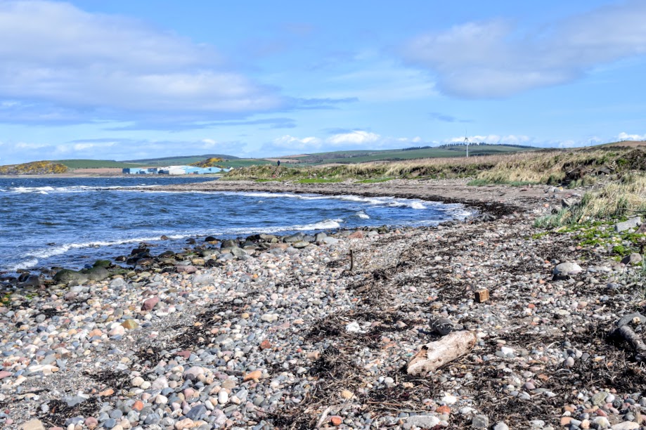
The next place of interest reached along the shoreline is a big blue factory! Sounds lovely, eh? 🙂 It might be a bit of a blight on the landscape, however it is an important part of the industry of this area and one of the main employers here. The ‘seaweed factory’, as it is known, is currently run by DuPont & IFF (International Flavours & Fragrances). In situ since 1943, its purpose was to extract alginate, found in brown seaweed, and process it into a thickener used in some foodstuffs, cosmetics and medicines.
The factory was located here due to its proximity to a plentiful supply of fresh water and its relative distance from the threat of German attack, rather than for a supply of seaweed! The seaweed was actually originally harvested from Orkney and the Western Isles however nowadays mostly comes from countries like Iceland, Australia and Norway where there is a more reliable and plentiful supply.
Extraction of the alginate from the seaweed takes place at a sister-site in Norway, with Girvan handling the processing of the alginate, blending it into the final products, carrying out testing and then exporting these around the world.
If you’d like to read more about it I recommend this excellent article by Ayrshire Magazine.
As you get closer to the factory you will come across the Dipple Burn which flows out onto the beach here. Often you will be able to easily ford it and continue your journey along the beach, however sometimes you might opt to take the short signposted inland de-tour out onto the main road and along past the front of IFF, re-joining the beach a little further along.

Back on firm sand it is time to settle in and enjoy easy walking pretty much all the way to Turnberry Lighthouse. Look out for seals basking on the rocks here – there were 5 of them on my last visit! And of course plenty of seabirds… I’ve noticed that they tend to all stand at the tide line (I assume this is where they source their food…) until I get too close for comfort at which point they take flight only to re-position themselves a little further along. Little do they know I am going that way too…. 🙂
Before you reach the lighthouse however, there are two more points of interest to look out for.
The first is the Balkenna bridge and ‘bield’ (shelter). You’ll find these where another burn crosses from land to sea and may or may not be fordable. If not, fear not, because the Ayrshire Coastal Path volunteers have been hard at work building a wooden footbridge over the burn for you – look out for a footpath on your right leading to this (can get overgrown in the summer). It was built in 2020. Also located here is a small building, formerly a water pump house belonging to the seaweed factory, which the volunteers have turned into a basic shelter: greatly appreciated on wet or windy days!

The second feature to look out for is the Milton Burn, and associated de-tour! You will find it where a large pipe crosses the golden sands of Turnberry Beach. Often you can’t see the burn until you’re at it, because it is hidden down a dip in the sand. As with the previous two burns, this one has a habit of filling up and becoming difficult to ford. So, back around 2008, the Ayrshire Coastal Path volunteers set about building some wooden steps up and over the sand dunes to take you around the back, across the burn, returning onto the beach at the other side.
Not only does this keep your feet dry, it is also an interesting place in its own right. The dunes here are recognised as a Site of Special Scientific Interest (SSSI). In the last inspection by NatureScot, some 92 species of beetle were found here, including some for which it is thought this might be the most northerly site in Britain.

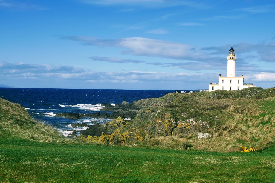
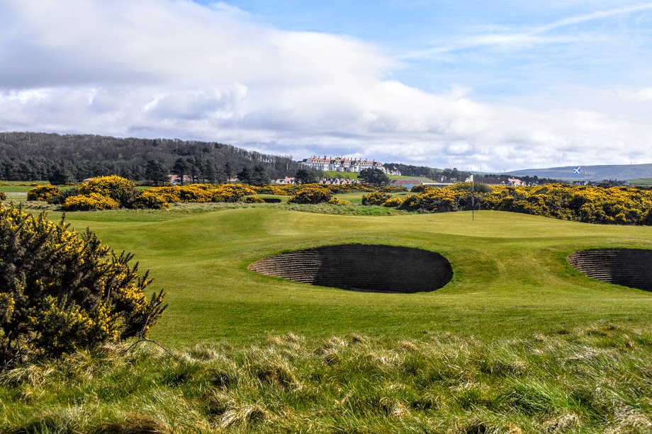
Onwards – towards Turnberry Lighthouse! You will have been able to see it for miles, seemingly never getting any closer. And now here you are! Well, not quite, as the Ayrshire Coastal Path route doesn’t actually go right up to the lighthouse. However you do get an excellent view of it as soon as you arrive onto Turnberry Golf Course. Once on ‘Lighthouse Road’ you could choose to take a de-tour along to the lighthouse. This would add approx 1 mile in total onto your route by the time you walk along and back.
Whatever your feelings about Donald Trump, there is no denying that the lighthouse looks spectacular! It was built in 1873 by the family of author Robert Louis Stevenson, amongst the ruins of Turnberry Castle, which incidentally is where Robert the Bruce was born in the 1200s! With the light now automated, the former keeper’s cottages have been converted into a small (expensive) tearoom – the halfway house for the golf course – with an outdoor seating area for good-weather days and a view to die for. The lighthouse building is actually the Penthouse for the Turnberry Hotel, and can therefore be booked for overnight stays.
The route cuts across this world-class golf course, between fairways and using maintenance vehicle access tracks. It is always perfectly manicured, a beautiful course. Even I (a non-golfer) can appreciate the beauty of it! Take note also of the black and gold Ayrshire Coastal Path signage here, instead of the usual green and white…. all to blend in with Trump’s colour scheme.
You will pass a couple of old aircraft landing strips on the golf course. These were used during the world wars when Turnberry was used as a training ground for RAF torpedo bombers. Many men lost their lives during these training exercises, and a war memorial dedicated to them can be seen as you cross the golf course.

The last part of the walk is an easy amble along the pavement into Maidens, where a small harbour awaits your arrival.
I can highly recommend both Ropes Bistro and Wildings Restaurant in Maidens. Ropes has always offered my walking groups a warm welcome and has a lovely outdoor seating area on a balcony overlooking the harbour. They serve light bites, pizzas, cakes, coffees and cold drinks – they are also licensed to serve alcohol. Wildings is a fairly upmarket restaurant and better suited if you are looking for a full meal and still looking (and smelling!) respectable after your day on the Ayrshire Coastal Path!