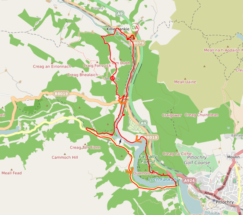
TERRAIN: a mix of surfaced roads and woodland paths and there are a lot of steps on this route.
![]() Dog-friendly route (Note some long sections on single track roads which may not appeal to all)
Dog-friendly route (Note some long sections on single track roads which may not appeal to all)
![]() Car park at Killiecrankie Visitor Centre (PH16 5LG). Closest train station is in Pitlochry, 4 miles away and from there the local bus service can be used to reach Killiecrankie, stopping outside the Visitor Centre.
Car park at Killiecrankie Visitor Centre (PH16 5LG). Closest train station is in Pitlochry, 4 miles away and from there the local bus service can be used to reach Killiecrankie, stopping outside the Visitor Centre.
View Full Route Description
Walk NW from the car park towards Killiecrankie Visitor Centre. Follow NTS signs for the Pass of Killiecrankie, going down some steps behind the Visitor Centre. You will soon reach a viewpoint. Just after crossing the railway line keep left (S) at a fork to go down some steps. At the bottom of the steps, at a path junction turn right (SW) to the Soldier’s Leap viewpoint. Head north from the viewpoint and turn left (NW) at a fork in the path to cross the railway line again and emerge onto B8079 just outside Killiecrankie Village. Cross the B8079 and continue straight ahead onto the driveway for the Killiecrankie Hotel. Almost immediately, turn left onto a woodland path which runs parallel to the B8079 until reaching the Village Hall. From the Village Hall continue NW along the pavement for 100m then turn left (S) onto a minor road, signposted “Killiecrankie Path, Garry Bridge”. This road crosses the railway line then the River Garry before arriving at a fork. Keep left (W), continuing to follow “Killiecrankie Path, Garry Bridge” signage uphill. A short 200m further up you will reach another fork. Follow the road as it bends round to the left (SE), once again signposted “Killiecrankie Path, Garry Bridge”. After approx 2km you will emerge onto the B8019. Turn left (NE) to pass the Garry Bridge Car Park then go down a set of steps beside the road bridge. An information board a the bottom of the steps welcomes you to the Linn of Tummel. Turn left (N) at the bottom of the steps and after approx 100m turn right (S) onto a path along the River Garry (path not shown on the map). Signage now says “Killiecrankie Path, Pitlochry”. The river should be on your left-hand side. Follow this trail along the River Garry for 1.2km, keeping left at any forks to stay as close to the river as you can most of the way along. The path starts to come away from the river and leads down to the banks of the River Tummel. You have the option of a short de-tour along to some rapids by crossing the footbridge and following the river upstream for 50m, returning via the same route. Head N back along the same path for approx 30m then turn left (W) along a narrow track which hugs a metal fence to begin with (path not shown on map) and takes you through the woods with the River Tummel on your left-hand side. Soon after going through a gate in a deer fence, you will arrive at a large suspension bridge. Cross the bridge then turn left (SE) to reach a single track road. Turn left (E) and walk along the road for 3.5km, passing the Clunie Arch and Power Station en route. Just before the road goes beneath the A9, turn left (N), signposted “Killiecrankie Path, Garry Bridge” and “Bealach Path”. Cross the footbridge over the River Tummel and at the other side turn left (W). The river should now be on your left-hand side. You will pass the former site of the Clunie Bridge and then cross a small wooden footbridge. 40m beyond the wooden footbridge, turn right (N) to go up some steps. Keep left at two forks 60m along from the top of the steps. A further 130m along, keep left at another fork. Follow signs for “Bealach Path, Killiecrankie” At another fork a short 40m along, keep right. 280m further along you will reach a section with 2 paths on your left in close proximity to each other. Take the first one (S), heading towards the southern tip of Loch Dunmore. Cross a bridge on your right after 60m, and continue to follow the path along the edge of the loch for 240m. The loch should be on your right-hand side. Cross Loch Dunmore via a large footbridge on your right (NE) then turn left (N) to walk along the water’s edge for another 180m. Continue on to a single track road and turn left (N) along the road for 730m. You soon have the River Tummel on your left-hand side. When you reach the Marine Scotland Freshwater Laboratory, turn left (SW) to come off the road and onto a woodland track (signposted “Bealach Path, Killiecrankie”). The water on your left as you walk along is once again the River Garry. Follow the path along the River Garry for approx 2km to where the path passes beneath the B8019 road bridge. A further 280m along from here there is a fork where you should turn left (N). The path now runs parallel to the railway line and gets really close to the viaduct. Just beyond the viaduct, at a fork keep right (W) to go up some steps. At the top of the steps keep right (NE). This takes you over the railway line and back to the viewpoint you were at earlier. At the bottom of some steps there is a fork. Both options take you back to the Visitor Centre. Turning right retraces your steps from the start: up the steps, across a bridge and up another set of steps. To avoid the steps keep left at the fork and turn right to walk along the roadside pavement until you arrive at Killiecrankie Visitor Centre.
WALK REVIEW: 7TH OCTOBER 2021
Both Killiecrankie and Faskally Forest had been listed in a newspaper article I read in Sept 2021 about top places to visit in Scotland in autumn. There were 19 places on the list, so to be able to tick two of them off in a oner was too tempting to resist, and I started planning.
Planning which took waaaaay to long….. I wanted to try and do a circular walk and it looked like there were paths on both sides of the River Garry apart from a teeny tiny section on the north west corner just outside Killiecrankie. From the map it looked as though the path just stopped all of a sudden with about half a mile to go, and that to get past you’d need to walk through someone’s property…. Often once you are on the ground there is a path which isn’t shown on the map so I was hoping that would be the case but it was a long way to walk to realise there’s no way through, so I also wanted to have a back-up plan.
In the end I designed a route using single track roads quite a distance away from the river on the way out, and following the river back. I also decided to walk the route anti-clockwise so that we could check out the missing path situation near the beginning rather than worry about it all day. Once there, it was immediately clear that there was no through-way to the river. The property in question even had a polite sign up indicating as much. So that was that decided!
The other thing which was immediately clear once there, was that we were a week or so too early to see Killiecrankie in all its autumn splendour :-(. The trees were only *just* beginning to change colour. A real shame since it was the whole purpose of our trip north today. We live and learn though so we got over it and were determined to enjoy the day nonetheless.
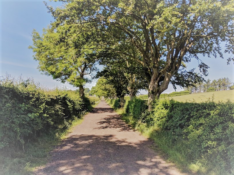
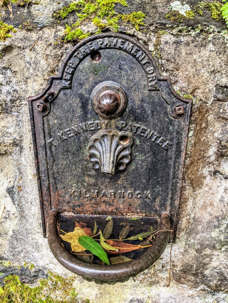
As it turned out, the road option was actually lovely, and the route really well signposted. Barely any traffic passed us the entire way and there were enough pretty farmhouses and cottages dotted along it for us to nosey at to keep things interesting. Passing Tenandry Church, we were delighted to spot a reminder of home built into the wall – a sort of metal water fountain with “Keep the Pavement Dry” embossed on it, as well as “T. Kennedy Patentee, Kilmarnock”!! We’d already joked about the fact that we’d left Killie (Kilmarnock) this morning, driven north for over 2hrs and ended up still in Killie (Killiecrankie). We didn’t for a second think we’d come across a historical item from our home town of Killie whilst here.
Points of interest along the River Garry section included the apparatus all set up for bungee jumps and zip wires! It turns out you can bungee off the B8019 road bridge, plunging towards the river below. Not for me I immediately concluded. Or you can speed across the river on a zip wire. Also not for me, although I’d be more open to that than a bungee I reckon. From the path along the river you get a really up-close-and-personal view of the equipment and a great sense of the height/distance. I imagine if you time it right and there are people taking part in these activities when you are there it would be very impressive to watch.
The Linn of Tummel is a beautiful area of woodland, where the River Garry merges with the River Tummel. Both are significant bodies of water: the Garry being a major tributary of the Tummel, and the Tummel being a tributary of the Tay. The Tummel plays an important role in the hydro-electric power scheme situated here. More on that shortly…
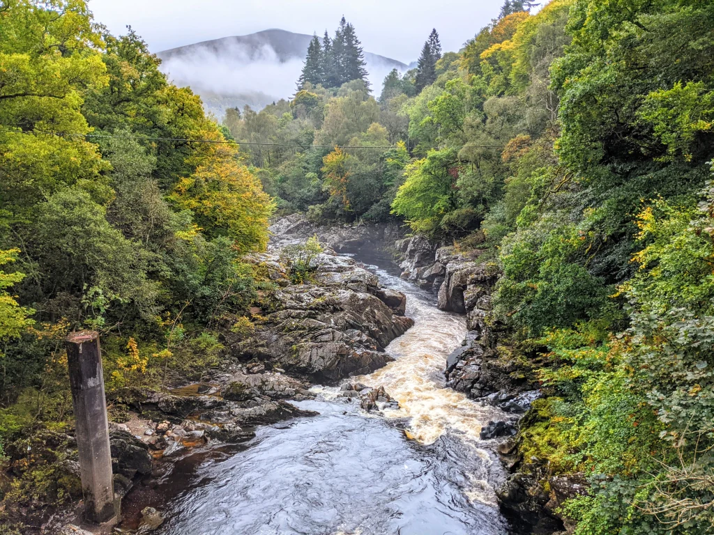
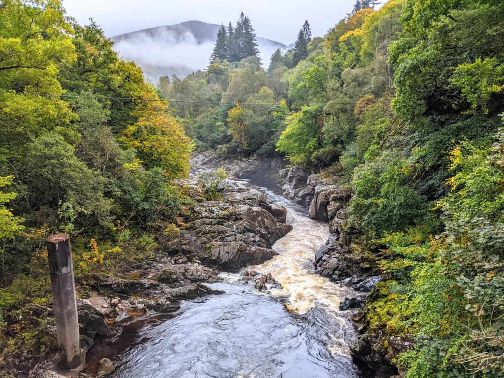
Following the path right to the end of the River Garry, we decided to take a de-tour because there was a trail going along the Tummel which we were curious to explore. It turned out to be a dead end, however not before taking us to some raging river rapids, a photo of which has ended up making it on to the cover of this post!
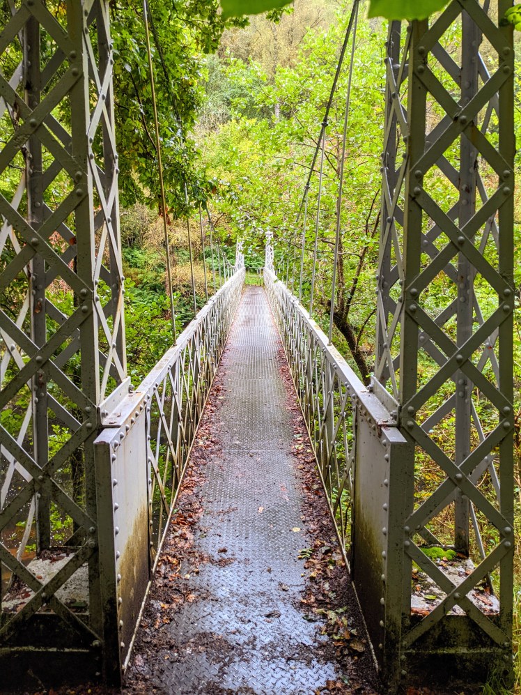
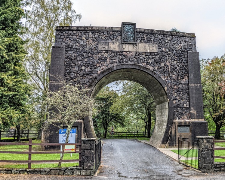
After crossing the Tummel via a suspension bridge (always a treat), we were back on a surfaced road for a while. The route took us past the entrance to Clunie Power Station. At the entrance is a huge memorial in the shape of an arch and the information board next to it explained that it was erected to honor the men who died in an accident here in the 1940s, whilst building a tunnel for the hydro-electric scheme. The circle of the archway measures the same width as the tunnel the men had been building.
It was at this point in the walk that I started to feel a hotspot on my left heel. I was wearing mum’s hiking boots because my own had been sent to Berghaus for a repair (I never did get them back but that is a story for another day). Mum had the exact same pair as me, same size and everything, and had bought them on my recommendation of them being like slippers (as had my sister, incidentally). In fact mum had only worn them a handful of times because they tended to hurt her left heel after a while….. I thought maybe they’d be ok on my feet since neither me nor my sister had experienced any problems with our own pairs, but as it turns out there must be a fault in this particular pair and I was glad to stop and put on some Compeed before things got any worse. The last time I had a blister was 5 years prior, whilst walking the Three Lochs Way and after that experience there was no way I was going to let another one slip through the net!
The next section took us through Faskally Forest and it wasn’t until we were there that I realised this is the location of the Enchanted Forest music and light show every October. Not every October, because this year and last year it couldn’t go ahead due to the covid-19 pandemic. Lucky for us, I thought, as I’m sure it would have looked a lot different if it had been taking place. My local country park in Kilmarnock has hosted a similar event over recent years (Illuminight) and walking through the park during the daytime you will find some paths closed off and those that are open have lots of electrical cables, security barriers and equipment along them. Wonderful by nightfall, but definitely takes away from the beauty of the place during daylight hours. As it happened though, we got to see Faskally Forest in all it’s natural splendour. There are actually loads of paths within these woods; somewhere you could return to as a walk in its own right, for sure.
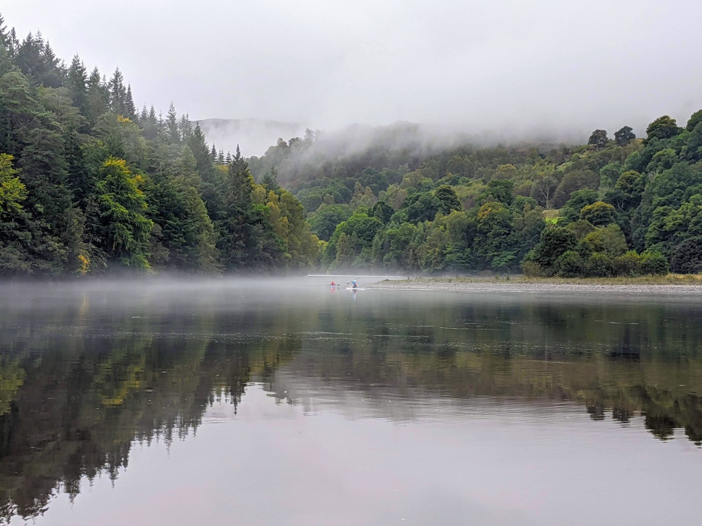
Emerging from the forest, the drizzly day we had been dealt showed us its silver lining. Mist had descended over the still water of the River Tummel, and as I stopped to take some photos (always on the lookout for my next calendar images!) two people on kayaks appeared from the River Garry and paddled off into the mist. It was a beautiful sight! A lovely end to a lovely day…