The only thing more romantic than a Valentine’s Day walk with your beloved, is a heart-shaped Valentine’s Day walk with your beloved! Below you will find a selection of routes I have written about which happen to be just that. Ok, so some of them are slightly loose-looking hearts, but a little imagination and I am sure you can make it work <3. Most of them are in Ayrshire, with one in Glasgow, one East Ren and one in Fife. Click the walk title to open up my website with turn-by-turn route information, photos and a report from my own experience of walking the route.
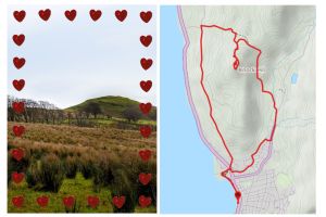
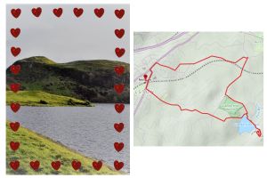
Knock Hill Circular, Largs: NORTH AYRSHIRE. By combining both the High and Low route options of the Ayrshire Coastal Path at Largs, you can create this circular route to the top of Knock Hill (268m / 879 ft) and back again. An easy first stage along Largs esplanade soon gives way to farm tracks and boggy hillside paths before a steep ascent to the summit trig point. Enjoy panoramic views across the Firth of Clyde to the Cowal Peninsula, southern Highlands, Isle of Cumbrae and Arran, as well as down into the town of Largs itself. The descent takes you West across farmland and through pleasant woodland then along a minor road behind Knock Castle.
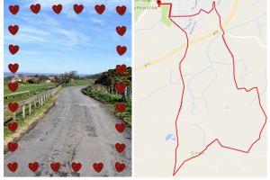
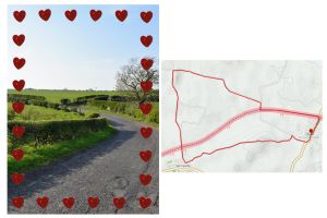
The Craigie Loop, Kilmarnock: EAST AYRSHIRE / SOUTH AYRSHIRE. On a clear day you will enjoy fantastic views as far as Ben Lomond on this walk! After an initial short section within the residential area of Shortlees in Kilmarnock, the route quickly heads out into the Ayrshire countryside where you remain for approximately 6 miles passing several working farms and through the village of Craigie. The entire walk is along quiet country roads however it is pretty hilly (promise it is all downhill after Craigie!) Some parts of Craigie Road are prone to flooding after heavy rainfall so wear suitable footwear.
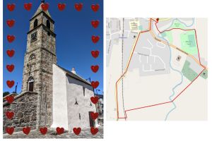
Kilmaurs Town Trail: EAST AYRSHIRE. A delightful short walk taking in some of Kilmaurs’ best bits, including Morton Park and the war memorial, St Maurs-Glencairn Parish Church, the remains of “Penny Bridge” and the impressive toolbooth known as the Jougs. It is actually much more of a countryside trail than its name suggests, including several field crossings. Wellies sometimes advisable!
The Craigie from Neilston: EAST RENFREWSHIRE. Duncarnock Fort (known locally as The Craigie) is a craggy hill (204 m / 669 ft) which stands invitingly on the banks of Glanderston Dam. Pausing on the summit of what was formerly an iron age fort, take a moment to wonder about it’s history and all that may have happened here many years ago! On a clear day, just as Mary Queen of Scots is rumoured to have done, you will enjoy panoramic views over greater Glasgow extending to the Campsies in the north. The route to the dam and the hill track can both be very boggy but the remainder of the walk is along surfaced minor roads and through the village of Neilston itself. (Note on last visit there was one locked gate which needed to be climbed).
Knockentiber/Springside Loop (longer option): EAST AYRSHIRE / NORTH AYRSHIRE. A great walk between the Ayrshire villages of Knockentiber and Springside. It starts along the dismantled Kilmarnock-Irvine railway track (NCN73 cycle track) before moving onto country roads. Lovely views down to Crosshouse and beyond from the highest point.
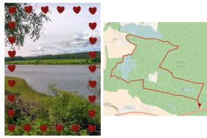
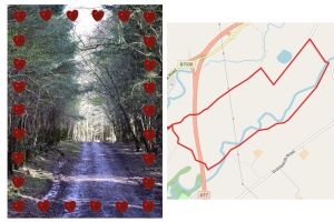
Peppermill Dam walk, Devilla Forest: FIFE. A multi-terrain circuit taking in two of the four lochs within Devilla Forest. Situated between Kincardine and Dunfermline, Devilla covers over 1700 acres of land and is one of the largest pine forests in the Scottish lowlands. On this walk you can expect wide gravel tracks and grassy footpaths throughout. Keep your eyes peeled for wildlife, in particular around the Moor Loch and Peppermill Dam areas!
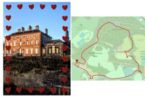
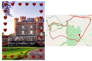
Pollok Country Park: GLASGOW. Home to one of Scotland’s grandest Edwardian country homes, Pollok House, and also to the world famous Burrell Collection, Pollok Country Park is the largest park in Glasgow. This circular walk takes you past both of these attractions, as well as through quiet woodlands and gardens, along the White Cart Water, through the Old Stable Courtyard, past the kids play area, and also visits the quirky Hobbit Village.
Eglinton Countryside Walk: NORTH AYRSHIRE. A pleasant woodland walk taking in some of the highlights of Eglinton Country Park before looping around Eglinton Loch and returning to the start via a track along the outer perimeter of the park.
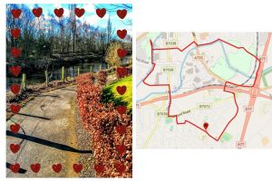
Caprington Castle, Kilmarnock: EAST AYRSHIRE. This is a really pleasant walk in Kilmarnock. It starts by crossing Caprington Golf Course on a grassy footpath to reach the village of Earlston and then follows a minor road along to pass Caprington Castle. From here you enter some woodland and visit the Walled Garden before following the River Irvine along (usually muddy) earth footpaths to the edge of Caprington housing estate.
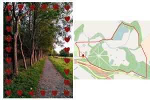
Craufurdland Countryside Walk: EAST AYRSHIRE. A walk for the more adventurous! Quiet country roads quickly lead into the woodland of Craufurdland Estate. You will pass the fishing loch and the Laird’s Table cafe/restaurant, as well as cross a ford (using the footbridge!) The return leg of the walk is via a public right of way across farmland. Expect a fair amount of mud in the woods most times of the year as well as 5 stiles to cross as you move along the field boundaries. To make it more of a heart shape, start from the Laird’s Table missing out the section along the Glasgow Road.
Kilmarnock South: EAST AYRSHIRE. An urban walk guiding you to parts of Kilmarnock you may never have seen before! The route also takes in the town’s popular Howard Park. Mostly on pavements, however there are two short sections which are earth tracks and can sometimes be muddy.