TERRAIN: A moderately challenging route with 459ft ascent/descent. Pavements, surfaced minor roads, rough farm tracks, grassy fields, grassy hillside. There are 3 stiles, one of which has the option of a kissing gate instead. To reach the hill summit requires a step over a wire fence that has been pushed down to knee height, or climb a metal gate. Sheep and cows graze the hillside.
![]() Dog-friendly route (Note: sheep and cows – please be a responsible dog owner. Several stiles which may be unsuitable for some dogs – see photos)
Dog-friendly route (Note: sheep and cows – please be a responsible dog owner. Several stiles which may be unsuitable for some dogs – see photos)
![]() GETTING THERE: The walk starts and ends at Maybole Train Station. Car parking available on Greenside opposite the station.
GETTING THERE: The walk starts and ends at Maybole Train Station. Car parking available on Greenside opposite the station.
![]() Toilets available inside the Carrick Centre next to Maybole Train Station
Toilets available inside the Carrick Centre next to Maybole Train Station

View full route description
From Maybole Train Station, cross Culzean Road and cut through the park (Greenside) onto School Vennel.
At the end of the street turn right to walk along B77/Whitehall for approx 300m to a 3-way junction. Veer left here, onto Coral Glen (traffic signs for Dailly and Kilkerran).
Stay on Coral Glen (which becomes Miller Terrace) for approx 500m, turning right onto Allan’s Hill when you are opposite the Dailly Road Store. This takes you uphill past Our Lady & St Cuthbert’s Parish Church.
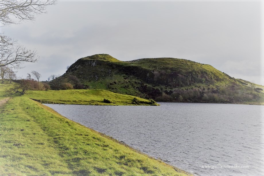
You will soon be out in the countryside, heading in a SW direction, with Kildoon Hill visible ahead.
Cross a small footbridge at a ford, then keep left at a split in the road to continue SW.
At the crossroads continue straight ahead (electricity sub station on the left, Glenside Farm on the right).
You now begin a gradual ascent, crossing the railway line and continuing along this quiet single track road for approx 1km. Keep an eye out for a gravel track on your right-hand-side with a green metal sign “Kildoon Hill, Kirkowsald”. Turn right here. Again a gradual ascent takes you ever closer to Kildoon Hill.
To reach the summit requires a small de-tour off the track. To do this, after passing a small fenced-off area at the edge of the field (marked on the OS map as a covered reservoir), look out for a gap in the field-boundary fence on your left where the fence wire has been pushed down low – see photo below. Alternatively a few paces further along there is a metal gate which you could climb. From here follow an indistinct trail to a gap in the dry stone wall and then up to the summit obelisk. Return to the main track by retracing your steps to the low bit of fence/metal gate and continue up to the end of the track.
The track ends at a gate/stile combo. Go over the stile/through the kissing gate and continue ahead in the same direction as before (SW) on a less defined track. There is a small loch on your right-hand-side.
This track suddenly becomes overgrown with gorse bushes, at which point you will need to come out to the right and walk parallel to it. When in line with the south end of the loch, you will reach a fence – there is a stile just to the left which will get you over it easily.
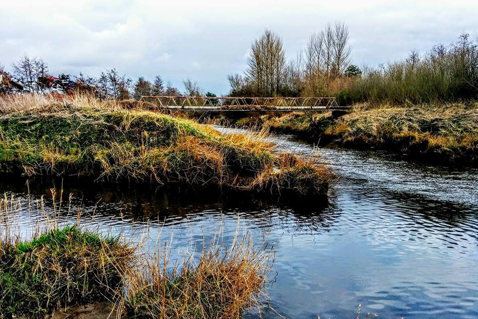
Walk down the field-edge, again parallel to the overgrown gorse track, to a footbridge over the Altewan Burn and then another stile.
Turn left (E) along the single track road (signposted “Kirkoswald”). Just beyond Lower Burncrooks Farm keep left at a fork (signposted “Maybole by road”).
At a fork in the road approx 250m beyond Spring Garden Farm, turn left (signposted “Maybole”). This road will eventually lead you back to the small footbridge at the ford.
At the bottom of Allan’s Hill, turn left onto Miller Terrace and retrace your steps from here to the train station.
WALK REPORT – 11th January 2025
I was heading to Maybole with a friend to catch a screening of the short film “Heart of the Biosphere: A Year in the Life of Merrick-Kells & Silver Flowe” which was having its ‘Ayrshire premier’ at the Carrick Centre. We had a catch up planned for this date, which normally involves a walk somewhere in Ayrshire, and so it was that today that place would be Maybole.
A quick Google search for ‘Maybole Walks’ took me to the South Ayrshire Paths Initiative website (SAPI), which introduced me to several routes I’d never done (or even heard of before, eek!). And I mean ‘eek’ in both the sense of ‘geez, how rude of me, I should at least have known that these existed‘ and ‘oooooh how exciting to have an unfamiliar place to explore!’
A quick bit of logistics ensued: Film screening 1.15pm…. Train to Maybole arriving at 10.45am…. That gave us about 2.5 hours for a walk, which immediately discounted three of the four walk options, leaving one: Kildoon Circuit 5 miles. We had the perfect plan! A walk within the Galloway & Southern Ayrshire UNESCO Biosphere followed by a film screening about the Biosphere.
So that’s the background to how we ended up on Kildoon Hill on 11th Jan 2025.
We’d had a fairly prolonged period of frosty weather in the lead up to today, so the icy pavements within the town didn’t come as any surprise. What was a very lovely surprise was that on Maybole’s country roads there was actually a fine coating of crunchy snow. There was to be a big thaw starting the next day, so I was lapping up every second of this relative winter wonderland whilst it lasted.
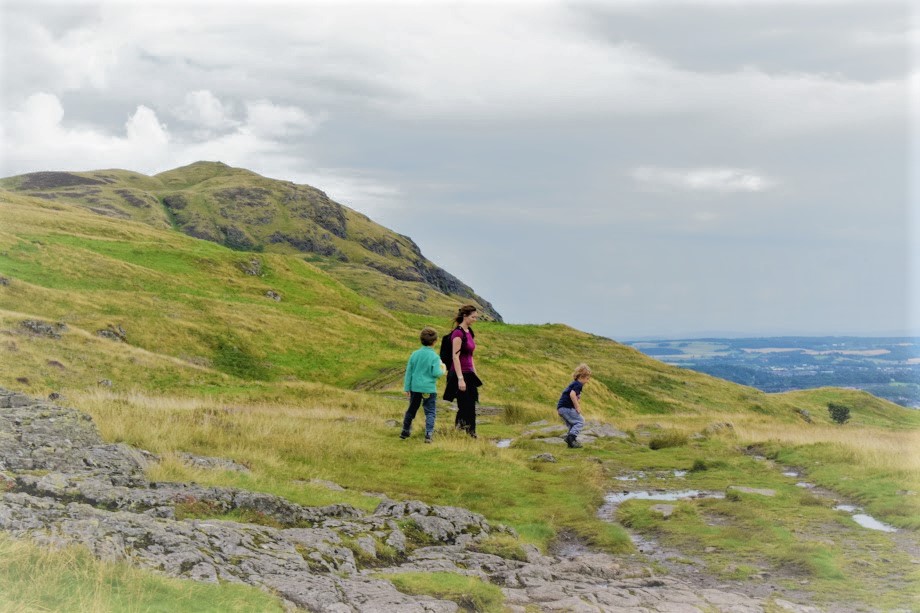
I had plotted out the route on Visorando whilst on the train in, using the instructions on the ‘Paths Around Maybole’ leaflet (downloaded from the SAPI website mentioned above). This came in really handy especially to get from the train station, through the town and out onto Allan’s Hill. From there we found the route to be pretty well signposted with the exception of the de-tour to the summit which required a bit of trial and error attempting to avoid some cows on the hillside and find a way over the fence that didn’t involve climbing any gates (just for you!) We also found the various stiles and gates to be in excellent condition. Great to see.
There was one short section after we came down off the summit which cased a small bit of confusion. We managed to figure out that the track where we were supposed to be walking had at some point become impassable due to gorse bushes. We could clearly see where we should have been walking, but we had to walk on the edge of the field instead. This is again where having the route on Visorando gave us some reassurance that we were headed in the right direction. I’ve made this available for you to download to your own phone so that you can follow it without having to plot it out yourself, just tap the purple ‘download/follow’ button above to access it. You’ll need to download the Visorando mapping app if you don’t already have it – it’s free to use.
Introduction to Digital Navigation is the course I have developed to teach you how to use mobile mapping apps like Visorando – sign up to learn how to plot routes on digital maps, how to follow a pre-plotted route like this one when you’re out on the trail, and how to create a trace of where you’re walking. Remove any uncertainty about whether you’re going the right way.
A mysterious sighting…..
As we walked along the track closest to the hill, we began to see small splodges of red in the snow. We were walking beneath some trees, and I didn’t look to see what type of trees they were but putting two and two together I thought these splodges must be berries which had been squished by whatever tractor or farm vehicle had recently come along here. But then I noticed the splodges were quite uniformly spread apart, and they continued even when we were out of the trees….. Were they drips? Of blood?? The imagination started to run wild at this point with all sorts of scenarios being conjured up in my head. I also had a feeling that I was glad not to be alone, afraid of what we might come across further up the trail! We never did figure out the source of the splodges, but we became convinced that they were indeed droplets of blood from something…. someone…. They eventually stopped as quickly as they started, and shall remain a mystery.
From the top of the hill we enjoyed panoramic snowy views over the rural South Ayrshire countryside before realising we’d better get a shimmy on if we wanted to be at the Carrick Centre in time for the film. We had taken 1.5hrs strolling along chatting and admiring the views, and we only had an hour to get back. Eek! At least it was all downhill….


Below are my photos of the three stiles on the route as well as the wooden footbridge. They are shown in the correct order if walking the circular route anti-clockwise as described above.