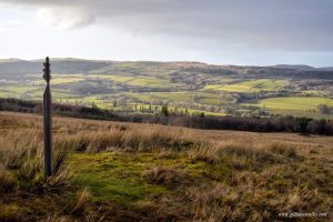
Walk 193 – Glen Sherup Horseshoe, The Ochils – 9.8 miles

Taking in the rolling summits of Innerdownie, Whitewisp Hill, Tarmangie Hill and – optionally – Ben Shee, this circular walk on the southern edge of Perth & Kinross offers a mixture of forest trails and open grassy hillside. It is best experienced on a clear day when the views can be appreciated to their fullest. … More Walk 193 – Glen Sherup Horseshoe, The Ochils – 9.8 miles

Walk 185 – Cornish Hill & its Loch – 3.4 miles

A brilliant and fairly easy circular walk from the Stinchar Bridge to the top of Cornish Hill, returning via the secluded and peaceful Cornish Loch. A good path the whole way, boggy in places. Fantastic views on a clear day! Parking at Stinchar Bridge car park, Straiton to Bargrennan Road. No public transport to start … More Walk 185 – Cornish Hill & its Loch – 3.4 miles

Walk 173 – Four Waters to Corlic Hill – 9.7 miles

This route is a combination of the Loch Thom Circular and the Corlic Hill walk, taking you past four of the reservoirs within Clyde Muirshiel Regional Park. It boasts a varied and very scenic 10 miles of rough trails, single track roads, grassy footpaths, and forestry trails and of course the added bonus of a hill (303 m / 994 ft). On a clear day you will be rewarded with the most spectacular views across the Clyde to the Cowal Peninsula and the Southern Highlands.  … More Walk 173 – Four Waters to Corlic Hill – 9.7 miles

Walk 170 – Barony Hill & the Quarry – 7 miles

Rural south Ayrshire at it’s best! Even the drive to the start of this walk is scenic and will leave you desperate to park up and head out! Awaiting you lie quiet country roads, muddy farm tracks and a steep ascent to the fantastic viewpoint atop Barony Hill (310m/1017ft). There is even an optional de-tour to visit the hidden remains of a impressive disused quarry and limekilns.  … More Walk 170 – Barony Hill & the Quarry – 7 miles

Walk 166 – Corlic Hill, Clyde Muirshiel Regional Park – 6 miles

A fantastic circuit at Scotland’s largest Regional Park. Good trails take you along to Corlic Hill summit (303 m / 994 ft) on the north-eastern perimeter of Clyde Muirshiel. On a clear day you will enjoy exceptional views down into the Clyde Valley, across to the Cowal Peninsula and over towards the southern Highlands. The return section of the route takes you past the ancient ruins of Burnhead and Glenbrae farmsteads and between the tranquil Gryfe reservoirs.  … More Walk 166 – Corlic Hill, Clyde Muirshiel Regional Park – 6 miles

Walk 164 – Brown Carrick Hill & The Ayrshire Coast – 8.2 miles

A combination of lowland hills and rocky coastlines: perfection in a walk! Starting in the picture-perfect fishing village of Dunure in south west Scotland, you will wind your way up into the Carrick Hills before descending to sea level to return to the beginning via one of the most stunning and rugged sections of the Ayrshire Coastal Path. On a clear day you will enjoy spectacular panoramic coastal views from the summit of Brown Carrick Hill (287 m / 941 ft): the best vantage point in the area! … More Walk 164 – Brown Carrick Hill & The Ayrshire Coast – 8.2 miles

Walk 160 – Knock Hill Circular, Largs – 8 miles

By joining two parts of the Ayrshire Coastal Path together, you can enjoy this circular route from Largs to the top of Knock Hill (268m / 879 ft) and back again. An easy first stage along Largs promenade soon gives way to farm tracks and boggy hillside paths before a steep ascent to the summit trig point. Enjoy panoramic views across the Firth of Clyde to the Cowal Peninsula, southern Highlands, Isle of Cumbrae and Arran, as well as down into the town of Largs itself. The descent takes you West across farmland and through pleasant woodland then along a minor road behind Knock Castle.  … More Walk 160 – Knock Hill Circular, Largs – 8 miles

Walk 158 – The Monument and Bennan Circuit, Straiton – 5 miles

Whilst in the village of Straiton you cannot help but wonder about the obelisk atop Craigengower (331m / 1086ft). This circular walk takes you up it’s steep slopes to the summit before a more gentle descent towards the Water of Girvan, returning to the start via pleasant riverside and woodland trails. This walk can be very boggy. Several kissing gates and one stile on the route.  … More Walk 158 – The Monument and Bennan Circuit, Straiton – 5 miles

Walk 155 – West Lomond & The Reservoirs – 4.7 miles

Climb up to the highest point in Fife on this incredibly scenic circular walk. The route begins by crossing a wide expanse of moorland before making the short but steep ascent of West Lomond (522m / 1712ft). Descending SE, enjoy the stunning views across to neighbouring East Lomond and the Harperleas and Ballo Reservoirs, both of which remain your companions for the return journey along a boggy path to the car park.  … More Walk 155 – West Lomond & The Reservoirs – 4.7 miles

Walk 150 – East Lomond & Maspie Den – 4.5 miles

One of my all-time favourite walks! First of all it’s a hill. Add to that the route being a loop and the return leg being down a stunningly beautiful glen complete with waterfall you actually walk behind… and you have nothing short of perfection! This is before we even talk about the quaint village of Falkland or the deep dark tunnel option. Read on to find out more! … More Walk 150 – East Lomond & Maspie Den – 4.5 miles

Walk 146 – Hill Wood Walk, Straiton – 4-6 miles

This is a circular walk beginning in the quaint rural Ayrshire village of Straiton. Initially the route heads uphill to follow rough and sometimes overgrown, boggy tracks through an area of forestry. Enjoy fine views down into the village and the Galloway hills beyond. The return leg of the walk loops back into Straiton on a variety of terrain including farm tracks, grassy fields and surfaced roads. … More Walk 146 – Hill Wood Walk, Straiton – 4-6 miles