Need a shorter option? You can shorten this walk by approx 1 mile by starting from Greenockmains Bridge (approx 5.5 miles). Alternatively you could split the walk at Wellwood: Limmerhaugh to Wellwood 3 miles then Wellwood to Kames 3.4 miles. Parking at Wellwood very limited, see below.
Feeling like a challenge? Try my Wellwood to Glenbuck Loch via Cairn Table walk (option to start earlier, at Limmerhaugh or finish earlier, at Kames)
TERRAIN: Graded Moderate. Grassy trails and farm tracks with several sections of boardwalk. Can become very boggy. No steep ascents or descents. Nine sets of steps – including some in poor state of repair with missing steps, as well as two bridges which have near vertical steps at each end. At least 15 kissing gates (see photos at bottom). Sheep often on the route.
![]() At Limmerhaugh there is space for approx 4 cars in a small lay-by at Limmerhaugh Farm and at Kames there is a small walkers car park. There are no public transport options to/from Limmerhaugh. Local bus services stop in Muirkirk approx 15 mins walk from the walk end point. If relying on public transport I suggest extending the walk and combining with the previous stage: Catrine-Limmerhaugh-Kames (then up to Muirkirk), since buses link Catrine and Muirkirk with one change. The walk would be approx 15 miles.
At Limmerhaugh there is space for approx 4 cars in a small lay-by at Limmerhaugh Farm and at Kames there is a small walkers car park. There are no public transport options to/from Limmerhaugh. Local bus services stop in Muirkirk approx 15 mins walk from the walk end point. If relying on public transport I suggest extending the walk and combining with the previous stage: Catrine-Limmerhaugh-Kames (then up to Muirkirk), since buses link Catrine and Muirkirk with one change. The walk would be approx 15 miles.
![]() There are no public toilets between Limmerhaugh and Kames.
There are no public toilets between Limmerhaugh and Kames.

View full route description
From the lay-by at Limmerhaugh Farm go down a set of steps towards the the river. Turn left and with the river on your right-hand side, follow the trail along the banks of the river Ayr to Greenockmains Bridge. Cross the bridge and pick up the continuation of the route at the other side via a kissing gate.
On arrival at Airds Moss, cross the bridge then follow a grassy path across Airds Moss for approx 1.5 miles, keeping the river to your left. Cross to the other side via another high bridge and then follow this trail to a kissing gate leading to a minor road.
Turn right to cross the river via a road bridge and before reaching the A70, turn left through another kissing gate and across a small footbridge. Continue ahead through some pine trees (the path runs parallel to the A70 but well away from it). You’ll soon arrive at another kissing gate where you cross the A70 and pick up the path again at the other side.
Follow the tracks through more pine trees, with the occasional view of a large flooded quarry site. This trail leads you back down to the river and onto a scenic grassy path interspersed with patches of boardwalk.
After going up some steps you’ll briefly enter some woodland followed by some more pleasant riverside walking. The path begins to veer away from the river when you reach a large wooden gate. Turn right here and then left onto a wider track through some trees.
On arrival at a large metal gate, go through the kissing gate then turn right to cross a field, staying close to a dry stone wall which will run along your left-hand-side. Go through another kissing gate at the far end of the field then turn left to begin walking along the disused railway track. This is easy walking for a little over half a mile, with lovely views towards Cairn Table and the village of Smallburn.
At the end of the track go down some steps then turn right along a track. Keep left at a fork to head for Tibby’s Brig. Cross the bridge then head uphill. You’ll see Muirkirk Golf Course on your left, and just beyond this point you have the option to turn right for a short de-tour (approx 300m each way) to Macadam’s Cairn or turn left to go through a gate and onto a good track leading towards Kames Racecourse and the walkers car park.
Walk Report: 26th April 2025
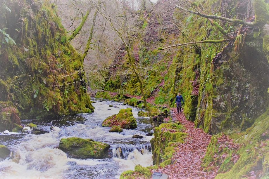
This might possibly be my favourite section of the River Ayr Way. Just such lovely scenery, very rural, and lots of points of interest along the way. Even on a dreich Saturday such as the day I found myself there most recently!
The River Ayr really begins to narrow around this area, and one of the reasons I love walking the route in this direction is the excitement of seeing it go gradually from raging river to bonnie burn. Much of today’s walk is along riverside trails which are gentle, wide and grassy. We were fortunate to be there when the ground was pretty dry however there were signs that boggy might be the word of the day a lot of the time.
It is also pretty well signposted with little chance of going wrong. If you’re concerned of course, be sure to access the digital map I’ve prepared for you to follow on the Visorando app.
The very special habitat of Airds Moss is reached soon after the walk begins, and my group was amazed at how many birds do indeed use this area. We were there during nesting season so it was particularly busy and using our Merlin apps we were able to identify the sound of numerous species. Walking through such a peaceful spot, it is hard to believe that Airds Moss was the site of a battle in the late 1600s which resulted in the death of nine Covenanters – lots of information about this is provided on an information board at the entrance to the reserve. There is a memorial here, which we believe might be the cairn we saw across the other side of the river in a field with grazing sheep.

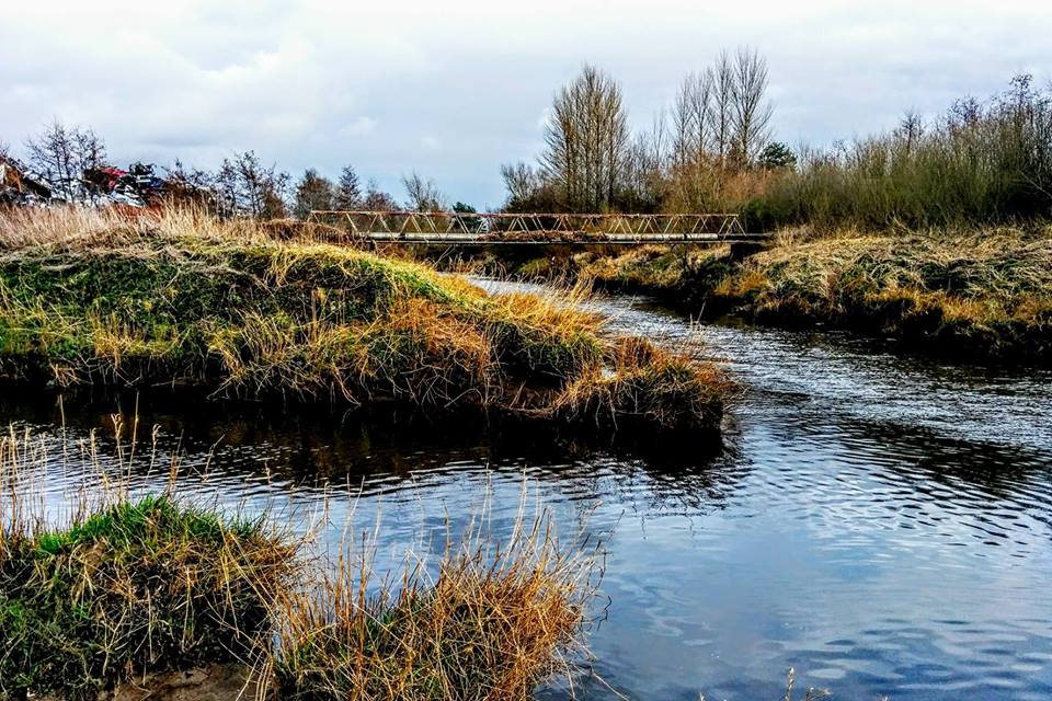
Also at Airds Moss are two footbridges of giant proportions! We weren’t really sure why they had to be such big structures. It is the steps up and down which are particularly unique – think of a ladder and you pretty much have the right idea…. If you are reading this and know why they were built like this do get in touch 🙂

Leaving Airds Moss behind, we came to an information board about the Muirkirk Poets’ Trail – most of which we’d walk today, by chance. It takes you past places associated with poets who had connections to Muirkirk as well as places with important heritage connections.

The pine woods were a real treat! We found a bird’s egg shell, which we think may have belonged to a Crow. There were lots of fallen trees around, not blocking the path, but which provided an excellent bench for our large group to sit for lunch!

After this it was back down to the riverside for arguably some of the most scenic views of our walk so far. Along this stretch we did encounter a fallen tree, which we had to negotiate with a bit of shimmying over and under branches.
And then a surprise section of dense native woodland – Birch trees I think – which on a damp day like today was particularly atmospheric.

Strolling along the disused railway track was a delight. We could see Cairn Table ahead – and off to the left the village of Smallburn. The going was easy, flat, perfect. We even spotted a herd of goats over the fence – they came running down towards us but then seemed to stop abruptly as though they had realised we weren’t who they thought we were.

Tibbie’s Brig was next up – what a delightful spot! We spent some time here reading the plaques and absorbing the tranquillity of the whole scene. Imagine living out here, as Isabel “Tibbie” Pagan once had! A poetess, who lived in Burns’ time, Tibbie was said to have ” a very unearthly appearance” due to a disability, a squint and a large tumour on her side. It is said that she ran an alehouse here and entertained her customers (mineworkers and the like – also possibly Burns himself) by reciting and signing poetry she had written herself. I’ve read that she had a lovely singing voice. In any case, what a lovely place to reside, if perhaps a little lonely…

A short de-tour to see Macadam’s Cairn was a must, since it is located really close to the route. We were surprised to learn that John Loudoun Macadam was in fact not known for the concept of covering roads in tarmac…. What he did invent was the macadam road surface: the idea of building roads using layers of different sized stones compacted, adopted the world over.

Boardwalk, steps and gates on this walk:


Next section: Muirkirk to Glenbuck Loch
Previous section: Catrine to Limmerhaugh
Whole route: River Ayr Way