Need a shorter option? Split the walk at Sorn: 2.5 miles from Catrine to Sorn, then 5.5 miles Sorn to Limmerhaugh. For a circular walk why not try my Catrine to Sorn Loop!
TERRAIN: Graded Moderate. Paved surfaces, earth woodland trails, boardwalk, grassy moorland. At the time of writing, much of the boardwalk was in a bad state of repair with loose planks and wire mesh. The woodland trails and moorland can be boggy. A couple of steep bits, three sets of steps (one of them long, one of them very boggy/waterlogged), several kissing gates, two ‘squeeze gates’ (see photos at bottom).
![]() Parking in Catrine available in St Germain Street car park. If splitting the route at Sorn, there’s plenty of on-street parking around about the primary school. At Limmerhaugh there is space for approx 4 cars in a small lay-by at Limmerhaugh Farm. Local bus services stop in Catrine however there are no public transport options to/from Sorn or Limmerhaugh.
Parking in Catrine available in St Germain Street car park. If splitting the route at Sorn, there’s plenty of on-street parking around about the primary school. At Limmerhaugh there is space for approx 4 cars in a small lay-by at Limmerhaugh Farm. Local bus services stop in Catrine however there are no public transport options to/from Sorn or Limmerhaugh.
![]() There are no public toilets on this route. In Catrine there are customer toilets inside the A.M. Brown Institute (close to the start point but a little off-route) and in the Honey Bee Cafe on St Germain Street. In Sorn there are customer toilets at the Country Corner cafe. None at all between Sorn and Limmerhaugh.
There are no public toilets on this route. In Catrine there are customer toilets inside the A.M. Brown Institute (close to the start point but a little off-route) and in the Honey Bee Cafe on St Germain Street. In Sorn there are customer toilets at the Country Corner cafe. None at all between Sorn and Limmerhaugh.

View full route description
From Mill Square in Catrine, turn right along St Germain Street. Take the first left onto Ayr Street, following the River Ayr along for 160m to a fork. Keep left at the fork and walk uphill on St Cuthbert’s Street.
At the end of the first terrace of houses 200m along, cross the bridge on your right then turn left to enter Catrine Voes and Woodlands Local Nature Reserve. After exiting the Nature Reserve, continue straight ahead to cross a small car park then turn right to cross a footbridge over the River Ayr.
Turn left along the trail, passing Catrine Weir on your left-hand-side. The footpath then continues through a pleasant woodland – keep the River Ayr to your left at any forks.
When you reach a minor road after 1.7km, turn left and follow the road downhill for 300m to the Auld Brig in Sorn. Cross the bridge and turn right to walk along the pavement beside B743/Main Street.
Continue all the way to the very eastern end of the village. Just after the pavement runs out, look out for a metal ‘squeeze gate’ across the road, leading into the woods. Follow the trail through the woodland, soon meeting up with the River Ayr again, after which a series of boardwalks takes you over some marshy ground.
Enjoy this very pleasant riverside trail, passing some old lime kilns and crossing several sections of boardwalk, steps and footbridges in varying states.
Approx 5km into the walk, after an ascent, there’s an old wooden River Ayr Way marker post covered in lichen. Unfortunately it only has one finger on it, and it points in the direction you’ve just come from. Here, continue ahead in the same direction you were going, ignoring paths on the left and right, to reach a deer fence. Follow this trail as it zig zags around the edge of a forest, emerging at a kissing gate.
After going through the gate turn right to follow a faint track across the grassy moorland to a small footbridge at a gate. Pick up the path on the other side of the gate and pass through a small tree plantation (can be very boggy).
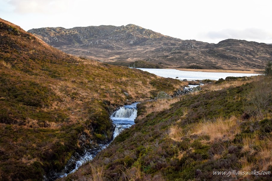
The next section of the walk is on high ground with splendid views down to the River Ayr and the surrounding countryside. A fairly steep descent takes you back down to the riverside (a particularly boggy section at the bottom) where a pleasant grassy trail leads you across boardwalk and through several gates.
On a slight incline there is a stile you need to use to cross a fence, and pick up the continuation of the path on the other side. There is one more squeeze gate before you reach the end of the walk at Fisherman’s Bridge – look out for a set of steps on your left leading up to the road and lay-by at Limmerhaugh Farm.
Walk Report: 22nd March 2025
Catrine is a place rich in history. And if I may say so, a very underrated walking destination! Today’s walk starts on Mill Square – the site of the former cotton mill which employed some 900 people at its peak. In fact there are links between the Catrine mill and the famous New Lanark mill, both founded by David Dale (of Stewarton). Standing reading the information boards in the square, I couldn’t help play one off against the other: New Lanark with its UNESCO world heritage site designation, and Catrine…. well, now just a memory.
I had been completely oblivious to the fact that Catrine had Voes and a Weir. I love that the community has done so much to preserve these features and create interpretation so that future generations can learn about them and gain appreciation for their importance to the village’s history. The walk through the Voes Local Nature Reserve isn’t technically part of the River Ayr Way (which goes along the neighbouring street), but I think it should be! It’s a joy to see the ducks and swans in the reservoirs and think back to a time when this was a working weir system powering the mill. Fascinating.


Then there’s the woodland walk to Sorn – wow. So peaceful. At times the river is so still the trees reflect in the water creating a mirror image.
Sorn is a charming wee village. From the grand entrance over the iconic hump-backed old stone bridge (which, unbelievably, cars still cross), to the old churchyard, rows of cottages and colourful main street. At the time of writing there were no shops in Sorn, no pubs, no public toilets, no buses! There is however a very lovely little cafe – Country Corner Sorn – where walkers receive a warm welcome and delicious scones. I highly recommend stopping in on your way through the village.

Some photos from Sorn:


Beyond Sorn, the River Ayr Way has a fabulously remote feel about it. Also a conflicting mixture of neglect and love: there are many boardwalks, gates and handrails in a state of disrepair, and amongst them brand new footbridges lined with non slip mats. My impression was that work is slowly taking place to repair all the broken bits, so hopefully East Ayrshire Leisure, who manage this part of the trail, have a plan…
The majority of this walk is down by the river or in view of the river and it is beautifully varied. The section which comes away from the riverside is a high-level walk with stunning views up the river valley. It makes an ideal lunch spot, if you don’t mind sitting in the heather beside the path: there is a lack of benches or anything to use as a seat on this stretch.


The end point of this walk is reached when you get to the suspension bridge known locally as Fisherman’s Bridge – you don’t need to cross it, the parking is up the steps to your left. If you’re brave enough to cross over though, there’s a lovely bench at the other side of the river which would be a great spot to enjoy an end-of-walk snack or drink overlooking the River Ayr.

Boardwalk, steps and gates on this walk:


Next section: Limmerhaugh to Kames (coming soon)
Previous section: Failford to Catrine
Whole route: River Ayr Way